Villa Hidalgo geodata
Villa Hidalgo (Chiapas) is a populated place; located in Mexico in America/Mexico_City (GMT-6) time zone. With population of 1,089 people, there are 7989 cities with bigger population in this country. Compared to other cities in Mexico, 99.2% of cities are located further ↑North; 92.9% of cities are located further ←West and 78.7% of cities have higher elevation than Villa Hidalgo. Note1


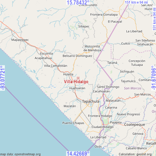
Villa Hidalgo GPS coordinates[2]
15° 6' 23.724" North, 92° 22' 26.688" West
| Map corner | latitude | longitude |
|---|---|---|
| Upper-left | 15.78432°, | -93.07721° |
| Center: | 15.10659°, | -92.37408° |
| Lower-right: | 14.42669°, | -91.67096° |
| Map W x H: | 151×151 km | = 93.8×93.8mi |
| max Lat: | 32.7° ⇑99.2% North |
| Villa Hidalgo: | 15.10659° |
| min Lat: | ⇓0.8% South 14.53588° |
| min Long | Villa Hidalgo | max Long |
| -117.105° | -92.37408° | -86.73105° |
| W 92.9%⇐ | ⇒7.1% E |
Elevation
Elevation of Villa Hidalgo is 116 m = 381 ft, and this is 1137.7 m = 3733 ft below average elevation for this country.
| Max E: |
3497 m = 11473 ft | 78.7% |
| Avg. | 1253.7 m = 4113 ft | |
| Villa Hidalgo | 116 m = 381 ft | |
Min E: |
-1 m = -3 ft | 21.3% |
See also: Mexico elevation on elevation.city.
Geographical zone
Villa Hidalgo is located in North Torrid zone (between Equator and Tropic of Cancer). Distance of this Northern Tropic circle is 926.2 km =575.5 mi to North.| Distance of | km | miles | from Villa Hidalgo |
|---|---|---|---|
| North Pole | 8327.4 | 5174.4 | to North |
| Arctic Circle | 5721.5 | 3555.2 | to North |
| Tropic Cancer | 926.2 | 575.5 | to North |
| Equator | 1679.7 | 1043.7 | to South |


Nearby cities:
15 places around Villa Hidalgo: (largest is in red/bold)
• Cantón Villaflor
2.5 km =1.6 mi,  69°
69°
• Chamulapa
6.7 km =4.2 mi,  208°
208°
• Chamulapita
4.2 km =2.6 mi,  173°
173°
• Cuarto Cantón
7.5 km =4.7 mi,  256°
256°
• El Chipilín
5.9 km =3.7 mi,  285°
285°
• Estación Tuzantán
8.2 km =5.1 mi,  269°
269°
• Francisco Sarabia 1ra. Sección
6.7 km =4.2 mi,  331°
331°
• Guadalupe Victoria
7.2 km =4.5 mi, 331°
• La Flor
8.6 km =5.3 mi,  301°
301°
• Manacal
7.7 km =4.8 mi,  358°
358°
• Primer Cantón
7.2 km =4.5 mi,  282°
282°
• Segundo Cantón
6.6 km =4.1 mi, 264°
• Tuzantán
6.9 km =4.3 mi,  310°
310°
• Xochiltepec
6.8 km =4.2 mi, 290°
• Zaragoza
7.8 km =4.8 mi, 69°
Sources, notices
• [Note1] Compared only with cities in Mexico existing in our database
• [Src1] Map data: © OpenStreetMap contributors (CC-BY-SA)
• [Src2] Other city data from geonames.org with taken over terms of usage.
• [Src3] Geographical zone / Annual Mean Temperature by Robert A. Rohde @ Wikipedia
