Coaxocotitla geodata
Coaxocotitla (San Luis Potosí) is a populated place; located in Mexico in America/Mexico_City (GMT-6) time zone. With population of 787 people, there are 11101 cities with bigger population in this country. Compared to other cities in Mexico, 79.2% of cities are located further ↓South; 54% of cities are located further ←West and 75.8% of cities have higher elevation than Coaxocotitla. Note1


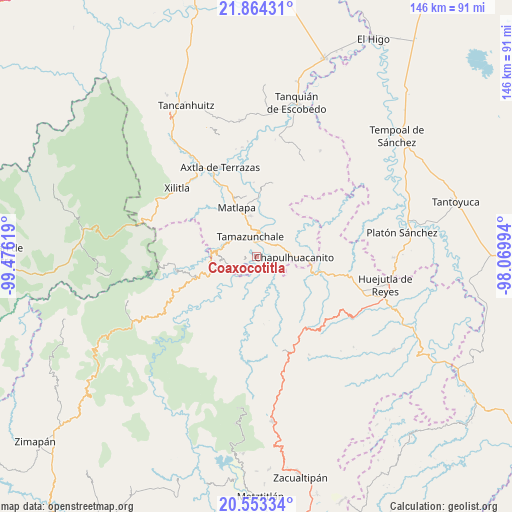
Coaxocotitla GPS coordinates[2]
21° 12' 37.008" North, 98° 46' 23.016" West
| Map corner | latitude | longitude |
|---|---|---|
| Upper-left | 21.86431°, | -99.47619° |
| Center: | 21.21028°, | -98.77306° |
| Lower-right: | 20.55334°, | -98.06994° |
| Map W x H: | 145.8×145.8 km | = 90.6×90.6mi |
| max Lat: | 32.7° ⇑20.8% North |
| Coaxocotitla: | 21.21028° |
| min Lat: | ⇓79.2% South 14.53588° |
| min Long | Coaxocotitla | max Long |
| -117.105° | -98.77306° | -86.73105° |
| W 54%⇐ | ⇒46% E |
Elevation
Elevation of Coaxocotitla is 194 m = 636 ft, and this is 1059.7 m = 3477 ft below average elevation for this country.
| Max E: |
3497 m = 11473 ft | 75.8% |
| Avg. | 1253.7 m = 4113 ft | |
| Coaxocotitla | 194 m = 636 ft | |
Min E: |
-1 m = -3 ft | 24.2% |
See also: Mexico elevation on elevation.city.
Geographical zone
Coaxocotitla is located in North Torrid zone (between Equator and Tropic of Cancer). Distance of this Northern Tropic circle is 247.6 km =153.9 mi to North.| Distance of | km | miles | from Coaxocotitla |
|---|---|---|---|
| North Pole | 7648.7 | 4752.7 | to North |
| Arctic Circle | 5042.8 | 3133.4 | to North |
| Tropic Cancer | 247.6 | 153.9 | to North |
| Equator | 2358.4 | 1465.4 | to South |


Nearby cities:
15 places around Coaxocotitla: (largest is in red/bold)
• Atlajque
3.2 km =2 mi,  277°
277°
• Axhumol
1.1 km =0.7 mi,  225°
225°
• Chantasco
5.1 km =3.2 mi,  151°
151°
• El Piñal
5.2 km =3.2 mi,  28°
28°
• Enramaditas
3.7 km =2.3 mi,  255°
255°
• Mecatlán
2.3 km =1.4 mi,  296°
296°
• Pemucho
6.1 km =3.8 mi, 256°
• Rancho Nuevo
4.9 km =3 mi,  103°
103°
• Santa María Picula
3.1 km =1.9 mi,  106°
106°
• Tamacol
6 km =3.7 mi, 296°
• Tamazunchale
5.8 km =3.6 mi,  342°
342°
• Temamatla
3 km =1.9 mi,  22°
22°
• Tezapotla
5.8 km =3.6 mi, 225°
• Tixcuayuca
5 km =3.1 mi, 233°
• Xalcuatla
3.2 km =2 mi,  159°
159°
Sources, notices
• [Note1] Compared only with cities in Mexico existing in our database
• [Src1] Map data: © OpenStreetMap contributors (CC-BY-SA)
• [Src2] Other city data from geonames.org with taken over terms of usage.
• [Src3] Geographical zone / Annual Mean Temperature by Robert A. Rohde @ Wikipedia
