Rancho Nuevo geodata
Rancho Nuevo (San Luis Potosí) is a populated place; located in Mexico in America/Mexico_City (GMT-6) time zone. With population of 605 people, there are 14228 cities with bigger population in this country. Compared to other cities in Mexico, 79.1% of cities are located further ↓South; 54.7% of cities are located further ←West and 70.8% of cities have higher elevation than Rancho Nuevo. Note1


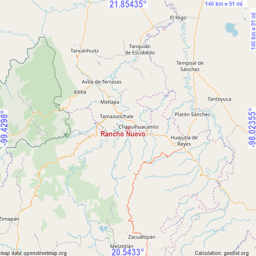
Rancho Nuevo GPS coordinates[2]
21° 12' 1.008" North, 98° 43' 36.012" West
| Map corner | latitude | longitude |
|---|---|---|
| Upper-left | 21.85435°, | -99.4298° |
| Center: | 21.20028°, | -98.72667° |
| Lower-right: | 20.5433°, | -98.02355° |
| Map W x H: | 145.8×145.8 km | = 90.6×90.6mi |
| max Lat: | 32.7° ⇑20.9% North |
| Rancho Nuevo: | 21.20028° |
| min Lat: | ⇓79.1% South 14.53588° |
| min Long | Rancho Nuevo | max Long |
| -117.105° | -98.72667° | -86.73105° |
| W 54.7%⇐ | ⇒45.3% E |
Elevation
Elevation of Rancho Nuevo is 377 m = 1237 ft, and this is 876.7 m = 2876 ft below average elevation for this country.
| Max E: |
3497 m = 11473 ft | 70.8% |
| Avg. | 1253.7 m = 4113 ft | |
| Rancho Nuevo | 377 m = 1237 ft | |
Min E: |
-1 m = -3 ft | 29.2% |
See also: Mexico elevation on elevation.city.
Geographical zone
Rancho Nuevo is located in North Torrid zone (between Equator and Tropic of Cancer). Distance of this Northern Tropic circle is 248.7 km =154.5 mi to North.| Distance of | km | miles | from Rancho Nuevo |
|---|---|---|---|
| North Pole | 7649.8 | 4753.4 | to North |
| Arctic Circle | 5043.9 | 3134.1 | to North |
| Tropic Cancer | 248.7 | 154.5 | to North |
| Equator | 2357.3 | 1464.8 | to South |


Nearby cities:
15 places around Rancho Nuevo: (largest is in red/bold)
• Axhumol
5.6 km =3.5 mi,  273°
273°
• Chantasco
4.1 km =2.5 mi,  215°
215°
• Chapulhuacanito
5.9 km =3.7 mi,  80°
80°
• Coaxocotitla
4.9 km =3 mi,  283°
283°
• Cojolapa
3.3 km =2.1 mi,  41°
41°
• El Palmito
5.8 km =3.6 mi,  18°
18°
• El Piñal
6.1 km =3.8 mi,  337°
337°
• Mecatlán
7.2 km =4.5 mi,  287°
287°
• Pahuayo
3.6 km =2.2 mi,  143°
143°
• Santa Lucía
4.7 km =2.9 mi,  153°
153°
• Santa María Picula
1.8 km =1.1 mi, 276°
• Temamatla
5.3 km =3.3 mi,  316°
316°
• Tezontla
5.4 km =3.4 mi, 35°
• Tianguispicula
2.4 km =1.5 mi,  116°
116°
• Xalcuatla
4.2 km =2.6 mi,  243°
243°
Sources, notices
• [Note1] Compared only with cities in Mexico existing in our database
• [Src1] Map data: © OpenStreetMap contributors (CC-BY-SA)
• [Src2] Other city data from geonames.org with taken over terms of usage.
• [Src3] Geographical zone / Annual Mean Temperature by Robert A. Rohde @ Wikipedia
