El Desierto geodata
El Desierto (Chiapas) is a populated place; located in Mexico in America/Mexico_City (GMT-6) time zone. With population of 554 people, there are 15392 cities with bigger population in this country. Compared to other cities in Mexico, 83.8% of cities are located further ↑North; 96% of cities are located further ←West and 77.7% of cities have higher elevation than El Desierto. Note1


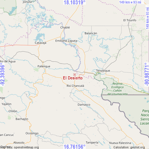
El Desierto GPS coordinates[2]
17° 26' 0.996" North, 91° 41' 26.988" West
| Map corner | latitude | longitude |
|---|---|---|
| Upper-left | 18.10319°, | -92.39396° |
| Center: | 17.43361°, | -91.69083° |
| Lower-right: | 16.76156°, | -90.98771° |
| Map W x H: | 149.2×149.2 km | = 92.7×92.7mi |
| max Lat: | 32.7° ⇑83.8% North |
| El Desierto: | 17.43361° |
| min Lat: | ⇓16.2% South 14.53588° |
| min Long | El Desierto | max Long |
| -117.105° | -91.69083° | -86.73105° |
| W 96%⇐ | ⇒4% E |
Elevation
Elevation of El Desierto is 138 m = 453 ft, and this is 1115.7 m = 3660 ft below average elevation for this country.
| Max E: |
3497 m = 11473 ft | 77.7% |
| Avg. | 1253.7 m = 4113 ft | |
| El Desierto | 138 m = 453 ft | |
Min E: |
-1 m = -3 ft | 22.3% |
See also: Mexico elevation on elevation.city.
Geographical zone
El Desierto is located in North Torrid zone (between Equator and Tropic of Cancer). Distance of this Northern Tropic circle is 667.5 km =414.8 mi to North.| Distance of | km | miles | from El Desierto |
|---|---|---|---|
| North Pole | 8068.6 | 5013.6 | to North |
| Arctic Circle | 5462.7 | 3394.4 | to North |
| Tropic Cancer | 667.5 | 414.8 | to North |
| Equator | 1938.4 | 1204.5 | to South |


Nearby cities:
15 places around El Desierto: (largest is in red/bold)
• Arena de Hidalgo
11.2 km =7 mi,  75°
75°
• Arimatea
22.2 km =13.8 mi,  242°
242°
• Benito Juárez Centro
18.8 km =11.7 mi,  358°
358°
• El Clavo
8.4 km =5.2 mi,  130°
130°
• Hermenegildo Galeana
17.1 km =10.6 mi,  218°
218°
• La Cascada
13.9 km =8.6 mi, 239°
• La Reforma de Ocampo
13.4 km =8.3 mi,  181°
181°
• Lázaro Cárdenas
16.8 km =10.4 mi,  118°
118°
• Miguel Hidalgo
17.6 km =10.9 mi,  308°
308°
• Nueva Galilea
21.5 km =13.4 mi,  233°
233°
• Nuevo San Joaquín
18.7 km =11.6 mi,  202°
202°
• Nuevo Sonora
20.8 km =12.9 mi,  266°
266°
• Río Chancalá
11 km =6.8 mi, 176°
• San Juan Chancalaíto
10.8 km =6.7 mi, 200°
• San Martín Chamizal
20.7 km =12.9 mi,  154°
154°
Sources, notices
• [Note1] Compared only with cities in Mexico existing in our database
• [Src1] Map data: © OpenStreetMap contributors (CC-BY-SA)
• [Src2] Other city data from geonames.org with taken over terms of usage.
• [Src3] Geographical zone / Annual Mean Temperature by Robert A. Rohde @ Wikipedia
