San Felipe geodata
San Felipe (State of Mexico) is a populated place; located in Mexico in America/Mexico_City (GMT-6) time zone. With population of 697 people, there are 12494 cities with bigger population in this country. Compared to other cities in Mexico, 66.2% of cities are located further ↑North; 59.5% of cities are located further →East and 75.4% of cities have lower elevation than San Felipe. Note1


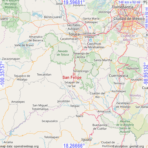
San Felipe GPS coordinates[2]
18° 55' 59.016" North, 99° 39' 15.984" West
| Map corner | latitude | longitude |
|---|---|---|
| Upper-left | 19.59681°, | -100.35757° |
| Center: | 18.93306°, | -99.65444° |
| Lower-right: | 18.26666°, | -98.95132° |
| Map W x H: | 147.9×147.9 km | = 91.9×91.9mi |
| max Lat: | 32.7° ⇑66.2% North |
| San Felipe: | 18.93306° |
| min Lat: | ⇓33.8% South 14.53588° |
| min Long | San Felipe | max Long |
| -117.105° | -99.65444° | -86.73105° |
| W 40.5%⇐ | ⇒59.5% E |
Elevation
Elevation of San Felipe is 2038 m = 6686 ft, and this is 784.3 m = 2573 ft above average elevation for this country.
| Max E: |
3497 m = 11473 ft | 24.6% |
| San Felipe | 2038 m 6686 ft | |
| Avg. | 1253.7 m = 4113 ft | |
Min E: |
-1 m = -3 ft | 75.4% |
See also: Mexico elevation on elevation.city.
Geographical zone
San Felipe is located in North Torrid zone (between Equator and Tropic of Cancer). Distance of this Northern Tropic circle is 500.8 km =311.2 mi to North.| Distance of | km | miles | from San Felipe |
|---|---|---|---|
| North Pole | 7901.9 | 4910 | to North |
| Arctic Circle | 5296 | 3290.8 | to North |
| Tropic Cancer | 500.8 | 311.2 | to North |
| Equator | 2105.2 | 1308.1 | to South |


Nearby cities:
15 places around San Felipe: (largest is in red/bold)
• Buenavista
1.4 km =0.9 mi,  349°
349°
• Coxcacoaco
3.7 km =2.3 mi,  49°
49°
• Ejido de San Mateo Coapexco
2.2 km =1.4 mi,  35°
35°
• El Islote
3.9 km =2.4 mi, 353°
• Jesús Carranza (Rancho de Jesús)
2.9 km =1.8 mi,  61°
61°
• La Finca
5 km =3.1 mi,  162°
162°
• La Joya
4.4 km =2.7 mi,  2°
2°
• La Lagunilla
4 km =2.5 mi,  99°
99°
• Potrero Nuevo
4.6 km =2.9 mi,  144°
144°
• San Francisco
2 km =1.2 mi,  22°
22°
• San Mateo Coapexco
4.4 km =2.7 mi,  316°
316°
• Santiago Oxtotitlán
3.5 km =2.2 mi,  335°
335°
• Tepetzingo
4.4 km =2.7 mi,  82°
82°
• Totolmajac
3.4 km =2.1 mi,  258°
258°
• Villa Guerrero
3.5 km =2.2 mi, 24°
Sources, notices
• [Note1] Compared only with cities in Mexico existing in our database
• [Src1] Map data: © OpenStreetMap contributors (CC-BY-SA)
• [Src2] Other city data from geonames.org with taken over terms of usage.
• [Src3] Geographical zone / Annual Mean Temperature by Robert A. Rohde @ Wikipedia
