Purungueo geodata
Purungueo (Michoacán) is a populated place; located in Mexico in America/Mexico_City (GMT-6) time zone. With population of 651 people, there are 13306 cities with bigger population in this country. Compared to other cities in Mexico, 64.3% of cities are located further ↑North; 72% of cities are located further →East and 69.5% of cities have higher elevation than Purungueo. Note1


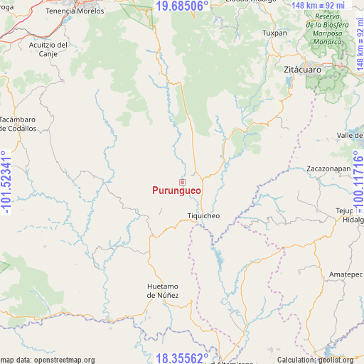
Purungueo GPS coordinates[2]
19° 1' 18.012" North, 100° 49' 13.008" West
| Map corner | latitude | longitude |
|---|---|---|
| Upper-left | 19.68506°, | -101.52341° |
| Center: | 19.02167°, | -100.82028° |
| Lower-right: | 18.35562°, | -100.11716° |
| Map W x H: | 147.8×147.8 km | = 91.8×91.8mi |
| max Lat: | 32.7° ⇑64.3% North |
| Purungueo: | 19.02167° |
| min Lat: | ⇓35.7% South 14.53588° |
| min Long | Purungueo | max Long |
| -117.105° | -100.82028° | -86.73105° |
| W 28%⇐ | ⇒72% E |
Elevation
Elevation of Purungueo is 440 m = 1444 ft, and this is 813.7 m = 2670 ft below average elevation for this country.
| Max E: |
3497 m = 11473 ft | 69.5% |
| Avg. | 1253.7 m = 4113 ft | |
| Purungueo | 440 m = 1444 ft | |
Min E: |
-1 m = -3 ft | 30.5% |
See also: Mexico elevation on elevation.city.
Geographical zone
Purungueo is located in North Torrid zone (between Equator and Tropic of Cancer). Distance of this Northern Tropic circle is 490.9 km =305 mi to North.| Distance of | km | miles | from Purungueo |
|---|---|---|---|
| North Pole | 7892.1 | 4903.9 | to North |
| Arctic Circle | 5286.2 | 3284.7 | to North |
| Tropic Cancer | 490.9 | 305 | to North |
| Equator | 2115 | 1314.2 | to South |


Nearby cities:
15 places around Purungueo: (largest is in red/bold)
• Angao
38.4 km =23.9 mi,  174°
174°
• Arroyo Grande
40.4 km =25.1 mi,  160°
160°
• Arroyo Seco
32 km =19.9 mi,  50°
50°
• Carácuaro
32 km =19.9 mi,  269°
269°
• Cañadas de Nanchititla
42.6 km =26.5 mi,  114°
114°
• Ceibas de Trujillo
20.6 km =12.8 mi, 107°
• El Campanario
42.5 km =26.4 mi,  88°
88°
• El Llano
16.6 km =10.3 mi,  329°
329°
• El Olivo
40.5 km =25.2 mi,  32°
32°
• La Parota
40.2 km =25 mi,  190°
190°
• Las Juntas del Tanque
23.8 km =14.8 mi, 45°
• Nocupétaro
36 km =22.4 mi, 273°
• Paso de Núñez (Buenavista)
19.4 km =12.1 mi,  223°
223°
• Tiquicheo
15.8 km =9.8 mi,  146°
146°
• Tuzantla
33.4 km =20.8 mi, 52°
Sources, notices
• [Note1] Compared only with cities in Mexico existing in our database
• [Src1] Map data: © OpenStreetMap contributors (CC-BY-SA)
• [Src2] Other city data from geonames.org with taken over terms of usage.
• [Src3] Geographical zone / Annual Mean Temperature by Robert A. Rohde @ Wikipedia
