El Llano geodata
El Llano (Michoacán) is a populated place; located in Mexico in America/Mexico_City (GMT-6) time zone. With population of 633 people, there are 13682 cities with bigger population in this country. Compared to other cities in Mexico, 62.2% of cities are located further ↑North; 72.7% of cities are located further →East and 65.6% of cities have higher elevation than El Llano. Note1


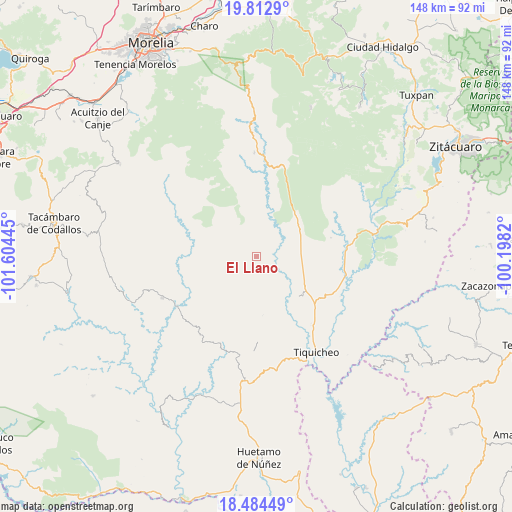
El Llano GPS coordinates[2]
19° 9' 0.108" North, 100° 54' 4.752" West
| Map corner | latitude | longitude |
|---|---|---|
| Upper-left | 19.8129°, | -101.60445° |
| Center: | 19.15003°, | -100.90132° |
| Lower-right: | 18.48449°, | -100.1982° |
| Map W x H: | 147.7×147.7 km | = 91.8×91.8mi |
| max Lat: | 32.7° ⇑62.2% North |
| El Llano: | 19.15003° |
| min Lat: | ⇓37.8% South 14.53588° |
| min Long | El Llano | max Long |
| -117.105° | -100.90132° | -86.73105° |
| W 27.3%⇐ | ⇒72.7% E |
Elevation
Elevation of El Llano is 657 m = 2156 ft, and this is 596.7 m = 1958 ft below average elevation for this country.
| Max E: |
3497 m = 11473 ft | 65.6% |
| Avg. | 1253.7 m = 4113 ft | |
| El Llano | 657 m = 2156 ft | |
Min E: |
-1 m = -3 ft | 34.4% |
See also: Mexico elevation on elevation.city.
Geographical zone
El Llano is located in North Torrid zone (between Equator and Tropic of Cancer). Distance of this Northern Tropic circle is 476.6 km =296.1 mi to North.| Distance of | km | miles | from El Llano |
|---|---|---|---|
| North Pole | 7877.8 | 4895 | to North |
| Arctic Circle | 5271.9 | 3275.8 | to North |
| Tropic Cancer | 476.6 | 296.1 | to North |
| Equator | 2129.3 | 1323.1 | to South |


Nearby cities:
15 places around El Llano: (largest is in red/bold)
• Arroyo Seco
33.9 km =21.1 mi,  79°
79°
• Carácuaro
27.6 km =17.1 mi,  238°
238°
• Ceibas de Trujillo
34.7 km =21.6 mi,  125°
125°
• El Olivo
36.3 km =22.6 mi,  56°
56°
• Etúcuaro
44.5 km =27.7 mi,  312°
312°
• Las Juntas del Tanque
25.5 km =15.8 mi, 84°
• Melchor Ocampo
39.6 km =24.6 mi,  251°
251°
• Nocupétaro
29.8 km =18.5 mi, 246°
• Paso de Núñez (Buenavista)
28.8 km =17.9 mi,  189°
189°
• Puente de Tierra
44.3 km =27.5 mi,  26°
26°
• Purungueo
16.6 km =10.3 mi,  149°
149°
• San Antonio Villalongín
45.5 km =28.3 mi,  20°
20°
• Tafetán
29.9 km =18.6 mi,  358°
358°
• Tiquicheo
32.4 km =20.1 mi, 147°
• Tuzantla
35.6 km =22.1 mi, 80°
Sources, notices
• [Note1] Compared only with cities in Mexico existing in our database
• [Src1] Map data: © OpenStreetMap contributors (CC-BY-SA)
• [Src2] Other city data from geonames.org with taken over terms of usage.
• [Src3] Geographical zone / Annual Mean Temperature by Robert A. Rohde @ Wikipedia
