Carácuaro geodata
Carácuaro (Michoacán) is a populated place; located in Mexico in America/Mexico_City (GMT-6) time zone. With population of 3,653 people, there are 2513 cities with bigger population in this country. Compared to other cities in Mexico, 64.4% of cities are located further ↑North; 74.4% of cities are located further →East and 67.7% of cities have higher elevation than Carácuaro. Note1


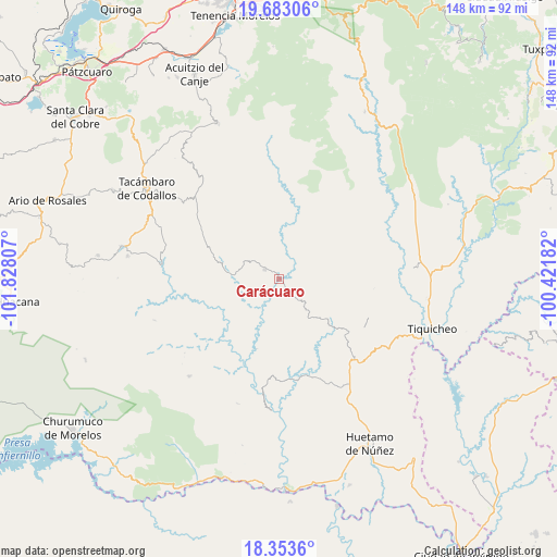
Carácuaro GPS coordinates[2]
19° 1' 10.776" North, 101° 7' 29.784" West
| Map corner | latitude | longitude |
|---|---|---|
| Upper-left | 19.68306°, | -101.82807° |
| Center: | 19.01966°, | -101.12494° |
| Lower-right: | 18.3536°, | -100.42182° |
| Map W x H: | 147.8×147.8 km | = 91.8×91.8mi |
| max Lat: | 32.7° ⇑64.4% North |
| Carácuaro: | 19.01966° |
| min Lat: | ⇓35.6% South 14.53588° |
| min Long | Carácuaro | max Long |
| -117.105° | -101.12494° | -86.73105° |
| W 25.6%⇐ | ⇒74.4% E |
Elevation
Elevation of Carácuaro is 544 m = 1785 ft, and this is 709.7 m = 2328 ft below average elevation for this country.
| Max E: |
3497 m = 11473 ft | 67.7% |
| Avg. | 1253.7 m = 4113 ft | |
| Carácuaro | 544 m = 1785 ft | |
Min E: |
-1 m = -3 ft | 32.3% |
See also: Mexico elevation on elevation.city.
Geographical zone
Carácuaro is located in North Torrid zone (between Equator and Tropic of Cancer). Distance of this Northern Tropic circle is 491.1 km =305.2 mi to North.| Distance of | km | miles | from Carácuaro |
|---|---|---|---|
| North Pole | 7892.3 | 4904 | to North |
| Arctic Circle | 5286.4 | 3284.8 | to North |
| Tropic Cancer | 491.1 | 305.2 | to North |
| Equator | 2114.8 | 1314.1 | to South |


Nearby cities:
15 places around Carácuaro: (largest is in red/bold)
• Canícuaro
40.3 km =25 mi,  305°
305°
• Chupio
38.1 km =23.7 mi,  297°
297°
• El Llano
27.6 km =17.1 mi,  58°
58°
• La Ermita (Nueva Jerusalén)
40.6 km =25.2 mi,  278°
278°
• La Loma
35.9 km =22.3 mi, 300°
• Las Hoyas Altas
39.1 km =24.3 mi, 307°
• Las Joyas (El Poblado)
38.3 km =23.8 mi, 302°
• Melchor Ocampo
14.2 km =8.8 mi, 277°
• Nocupétaro
4.7 km =2.9 mi, 304°
• Ojo de Agua de Chupio
33.9 km =21.1 mi,  292°
292°
• Paso de Núñez (Buenavista)
23.3 km =14.5 mi,  126°
126°
• Pedernales
38.6 km =24 mi, 290°
• Petembo
40.4 km =25.1 mi, 286°
• Purungueo
32 km =19.9 mi,  89°
89°
• Turicato
31.1 km =19.3 mi, 277°
Sources, notices
• [Note1] Compared only with cities in Mexico existing in our database
• [Src1] Map data: © OpenStreetMap contributors (CC-BY-SA)
• [Src2] Other city data from geonames.org with taken over terms of usage.
• [Src3] Geographical zone / Annual Mean Temperature by Robert A. Rohde @ Wikipedia
