Nocupétaro geodata
Nocupétaro (Michoacán) is a populated place; located in Mexico in America/Mexico_City (GMT-6) time zone. With population of 3,054 people, there are 2947 cities with bigger population in this country. Compared to other cities in Mexico, 64% of cities are located further ↑North; 74.7% of cities are located further →East and 65.4% of cities have higher elevation than Nocupétaro. Note1


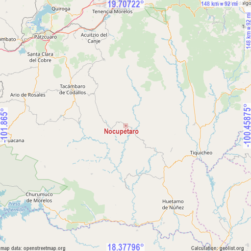
Nocupétaro GPS coordinates[2]
19° 2' 38.112" North, 101° 9' 42.732" West
| Map corner | latitude | longitude |
|---|---|---|
| Upper-left | 19.70722°, | -101.865° |
| Center: | 19.04392°, | -101.16187° |
| Lower-right: | 18.37796°, | -100.45875° |
| Map W x H: | 147.8×147.8 km | = 91.8×91.8mi |
| max Lat: | 32.7° ⇑64% North |
| Nocupétaro: | 19.04392° |
| min Lat: | ⇓36% South 14.53588° |
| min Long | Nocupétaro | max Long |
| -117.105° | -101.16187° | -86.73105° |
| W 25.3%⇐ | ⇒74.7% E |
Elevation
Elevation of Nocupétaro is 665 m = 2182 ft, and this is 588.7 m = 1931 ft below average elevation for this country.
| Max E: |
3497 m = 11473 ft | 65.4% |
| Avg. | 1253.7 m = 4113 ft | |
| Nocupétaro | 665 m = 2182 ft | |
Min E: |
-1 m = -3 ft | 34.6% |
See also: Mexico elevation on elevation.city.
Geographical zone
Nocupétaro is located in North Torrid zone (between Equator and Tropic of Cancer). Distance of this Northern Tropic circle is 488.4 km =303.5 mi to North.| Distance of | km | miles | from Nocupétaro |
|---|---|---|---|
| North Pole | 7889.6 | 4902.4 | to North |
| Arctic Circle | 5283.7 | 3283.1 | to North |
| Tropic Cancer | 488.4 | 303.5 | to North |
| Equator | 2117.5 | 1315.8 | to South |


Nearby cities:
15 places around Nocupétaro: (largest is in red/bold)
• Canícuaro
35.6 km =22.1 mi,  305°
305°
• Carácuaro
4.7 km =2.9 mi,  124°
124°
• Chupio
33.4 km =20.8 mi,  296°
296°
• El Llano
29.8 km =18.5 mi,  66°
66°
• La Ermita (Nueva Jerusalén)
36.4 km =22.6 mi,  275°
275°
• La Loma
31.2 km =19.4 mi, 299°
• Las Hoyas Altas
34.4 km =21.4 mi, 307°
• Las Joyas (El Poblado)
33.6 km =20.9 mi, 302°
• Melchor Ocampo
10.2 km =6.3 mi,  265°
265°
• Ojo de Agua de Chupio
29.3 km =18.2 mi,  290°
290°
• Paso de Núñez (Buenavista)
28.1 km =17.5 mi,  126°
126°
• Pedernales
34 km =21.1 mi, 288°
• Petembo
35.9 km =22.3 mi, 284°
• Purungueo
36 km =22.4 mi,  93°
93°
• Turicato
27 km =16.8 mi, 272°
Sources, notices
• [Note1] Compared only with cities in Mexico existing in our database
• [Src1] Map data: © OpenStreetMap contributors (CC-BY-SA)
• [Src2] Other city data from geonames.org with taken over terms of usage.
• [Src3] Geographical zone / Annual Mean Temperature by Robert A. Rohde @ Wikipedia
