Coscamila geodata
Coscamila (Guerrero) is a populated place; located in Mexico in America/Mexico_City (GMT-6) time zone. With population of 643 people, there are 13457 cities with bigger population in this country. Compared to other cities in Mexico, 84% of cities are located further ↑North; 53.1% of cities are located further →East and 62.9% of cities have higher elevation than Coscamila. Note1


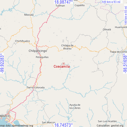
Coscamila GPS coordinates[2]
17° 25' 4.188" North, 99° 13' 10.92" West
| Map corner | latitude | longitude |
|---|---|---|
| Upper-left | 18.08747°, | -99.92283° |
| Center: | 17.41783°, | -99.2197° |
| Lower-right: | 16.74573°, | -98.51658° |
| Map W x H: | 149.2×149.2 km | = 92.7×92.7mi |
| max Lat: | 32.7° ⇑84% North |
| Coscamila: | 17.41783° |
| min Lat: | ⇓16% South 14.53588° |
| min Long | Coscamila | max Long |
| -117.105° | -99.2197° | -86.73105° |
| W 46.9%⇐ | ⇒53.1% E |
Elevation
Elevation of Coscamila is 825 m = 2707 ft, and this is 428.7 m = 1406 ft below average elevation for this country.
| Max E: |
3497 m = 11473 ft | 62.9% |
| Avg. | 1253.7 m = 4113 ft | |
| Coscamila | 825 m = 2707 ft | |
Min E: |
-1 m = -3 ft | 37.1% |
See also: Mexico elevation on elevation.city.
Geographical zone
Coscamila is located in North Torrid zone (between Equator and Tropic of Cancer). Distance of this Northern Tropic circle is 669.2 km =415.8 mi to North.| Distance of | km | miles | from Coscamila |
|---|---|---|---|
| North Pole | 8070.4 | 5014.7 | to North |
| Arctic Circle | 5464.5 | 3395.5 | to North |
| Tropic Cancer | 669.2 | 415.8 | to North |
| Equator | 1936.7 | 1203.4 | to South |


Nearby cities:
15 places around Coscamila: (largest is in red/bold)
• Achigca
6.5 km =4 mi,  345°
345°
• Ayahualulco
10 km =6.2 mi,  23°
23°
• Aztatepec
8 km =5 mi,  233°
233°
• Colotlipa
5.6 km =3.5 mi,  96°
96°
• Juxtlahuaca
7.9 km =4.9 mi,  80°
80°
• Ostocapa
3.3 km =2.1 mi, 352°
• Popoyatlajco
10.6 km =6.6 mi,  330°
330°
• Quechultenango
2.4 km =1.5 mi,  260°
260°
• San Martín
9.4 km =5.8 mi,  302°
302°
• San Miguel
10.1 km =6.3 mi, 300°
• San Ángel
9.2 km =5.7 mi,  38°
38°
• Santa Fe
2.4 km =1.5 mi, 102°
• Tlamixtlahuacan
9.5 km =5.9 mi,  356°
356°
• Tonalapa
8.4 km =5.2 mi,  343°
343°
• Xiloxuchicán
9 km =5.6 mi,  46°
46°
Sources, notices
• [Note1] Compared only with cities in Mexico existing in our database
• [Src1] Map data: © OpenStreetMap contributors (CC-BY-SA)
• [Src2] Other city data from geonames.org with taken over terms of usage.
• [Src3] Geographical zone / Annual Mean Temperature by Robert A. Rohde @ Wikipedia
