Miramar geodata
Miramar (Oaxaca) is a populated place; located in Mexico in America/Mexico_City (GMT-6) time zone. With population of 643 people, there are 13457 cities with bigger population in this country. Compared to other cities in Mexico, 88.9% of cities are located further ↑North; 66.1% of cities are located further ←West and 61.6% of cities have lower elevation than Miramar. Note1


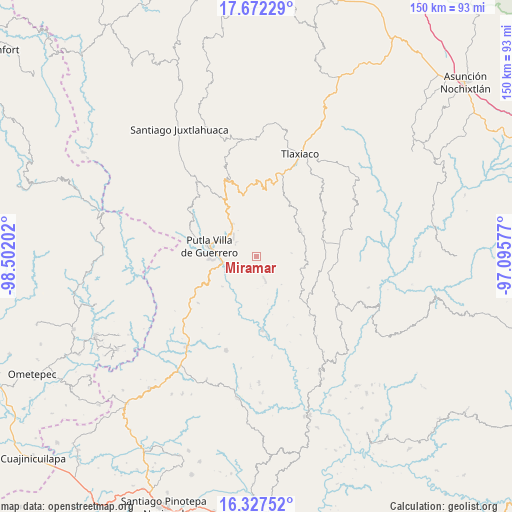
Miramar GPS coordinates[2]
17° 0' 3.996" North, 97° 47' 56.004" West
| Map corner | latitude | longitude |
|---|---|---|
| Upper-left | 17.67229°, | -98.50202° |
| Center: | 17.00111°, | -97.79889° |
| Lower-right: | 16.32752°, | -97.09577° |
| Map W x H: | 149.5×149.5 km | = 92.9×92.9mi |
| max Lat: | 32.7° ⇑88.9% North |
| Miramar: | 17.00111° |
| min Lat: | ⇓11.1% South 14.53588° |
| min Long | Miramar | max Long |
| -117.105° | -97.79889° | -86.73105° |
| W 66.1%⇐ | ⇒33.9% E |
Elevation
Elevation of Miramar is 1751 m = 5745 ft, and this is 497.3 m = 1632 ft above average elevation for this country.
| Max E: |
3497 m = 11473 ft | 38.4% |
| Miramar | 1751 m 5745 ft | |
| Avg. | 1253.7 m = 4113 ft | |
Min E: |
-1 m = -3 ft | 61.6% |
See also: Mexico elevation on elevation.city.
Geographical zone
Miramar is located in North Torrid zone (between Equator and Tropic of Cancer). Distance of this Northern Tropic circle is 715.6 km =444.7 mi to North.| Distance of | km | miles | from Miramar |
|---|---|---|---|
| North Pole | 8116.7 | 5043.5 | to North |
| Arctic Circle | 5510.8 | 3424.3 | to North |
| Tropic Cancer | 715.6 | 444.7 | to North |
| Equator | 1890.3 | 1174.6 | to South |


Nearby cities:
15 places around Miramar: (largest is in red/bold)
• Agua del Toro
8.8 km =5.5 mi,  96°
96°
• Concepción del Progreso
8.4 km =5.2 mi,  306°
306°
• La Zafra
9.7 km =6 mi,  259°
259°
• Malpica
11.8 km =7.3 mi,  275°
275°
• Putla Villa de Guerrero
14.1 km =8.8 mi, 281°
• San Juan Lagunas
14 km =8.7 mi,  268°
268°
• San Juan Teponaxtla
7 km =4.3 mi,  298°
298°
• San Miguel Reyes
13.4 km =8.3 mi,  228°
228°
• San Pedro Siniyuvi
4.8 km =3 mi,  247°
247°
• San Sebastián Nopalera
6.8 km =4.2 mi,  160°
160°
• Santa María Ocotlán
8.4 km =5.2 mi,  120°
120°
• Santa María Yucuhiti
3.7 km =2.3 mi,  57°
57°
• Santiago Nuyoó
3.7 km =2.3 mi,  66°
66°
• Yutecoso Cuauhtémoc
13.6 km =8.5 mi,  129°
129°
• Zimatlán
7.8 km =4.8 mi,  206°
206°
Sources, notices
• [Note1] Compared only with cities in Mexico existing in our database
• [Src1] Map data: © OpenStreetMap contributors (CC-BY-SA)
• [Src2] Other city data from geonames.org with taken over terms of usage.
• [Src3] Geographical zone / Annual Mean Temperature by Robert A. Rohde @ Wikipedia
