Tlachimaltepec geodata
Tlachimaltepec (Guerrero) is a populated place; located in Mexico in America/Mexico_City (GMT-6) time zone. With population of 620 people, there are 13925 cities with bigger population in this country. Compared to other cities in Mexico, 83.3% of cities are located further ↑North; 50.1% of cities are located further →East and 70.4% of cities have lower elevation than Tlachimaltepec. Note1


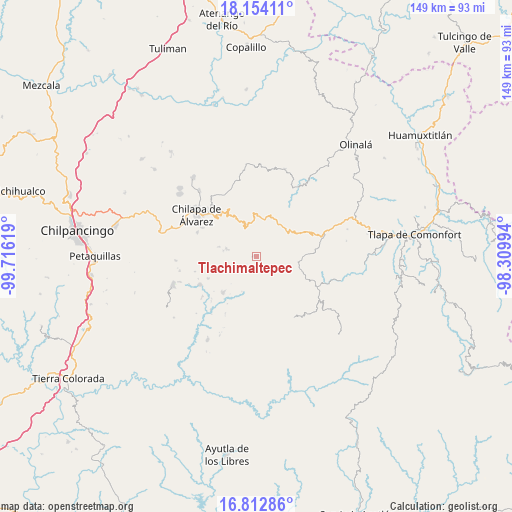
Tlachimaltepec GPS coordinates[2]
17° 29' 4.992" North, 99° 0' 47.016" West
| Map corner | latitude | longitude |
|---|---|---|
| Upper-left | 18.15411°, | -99.71619° |
| Center: | 17.48472°, | -99.01306° |
| Lower-right: | 16.81286°, | -98.30994° |
| Map W x H: | 149.1×149.1 km | = 92.6×92.6mi |
| max Lat: | 32.7° ⇑83.3% North |
| Tlachimaltepec: | 17.48472° |
| min Lat: | ⇓16.7% South 14.53588° |
| min Long | Tlachimaltepec | max Long |
| -117.105° | -99.01306° | -86.73105° |
| W 49.9%⇐ | ⇒50.1% E |
Elevation
Elevation of Tlachimaltepec is 1933 m = 6342 ft, and this is 679.3 m = 2229 ft above average elevation for this country.
| Max E: |
3497 m = 11473 ft | 29.6% |
| Tlachimaltepec | 1933 m 6342 ft | |
| Avg. | 1253.7 m = 4113 ft | |
Min E: |
-1 m = -3 ft | 70.4% |
See also: Mexico elevation on elevation.city.
Geographical zone
Tlachimaltepec is located in North Torrid zone (between Equator and Tropic of Cancer). Distance of this Northern Tropic circle is 661.8 km =411.2 mi to North.| Distance of | km | miles | from Tlachimaltepec |
|---|---|---|---|
| North Pole | 8062.9 | 5010.1 | to North |
| Arctic Circle | 5457.1 | 3390.9 | to North |
| Tropic Cancer | 661.8 | 411.2 | to North |
| Equator | 1944.1 | 1208 | to South |


Nearby cities:
15 places around Tlachimaltepec: (largest is in red/bold)
• Ahuixtla
5.6 km =3.5 mi,  334°
334°
• Alcozacán
9 km =5.6 mi,  284°
284°
• Apanguito
5.2 km =3.2 mi,  143°
143°
• Ayahualtempa
3.9 km =2.4 mi,  220°
220°
• Cacahuatepec
10.9 km =6.8 mi,  154°
154°
• Hueycantenango
4.2 km =2.6 mi,  196°
196°
• Ixcatla
7.1 km =4.4 mi,  168°
168°
• Mazazontecomac
5.3 km =3.3 mi,  126°
126°
• Petatlán
11 km =6.8 mi,  13°
13°
• San Jerónimo Palantla
9.3 km =5.8 mi,  301°
301°
• Tepozonalco
9.9 km =6.2 mi,  349°
349°
• Tlalchichiltipán Nuevo
9.7 km =6 mi, 171°
• Tomactilicán
3.3 km =2.1 mi, 151°
• Zelocotitlán
10.8 km =6.7 mi,  246°
246°
• Zompeltepec
9.9 km =6.2 mi, 327°
Sources, notices
• [Note1] Compared only with cities in Mexico existing in our database
• [Src1] Map data: © OpenStreetMap contributors (CC-BY-SA)
• [Src2] Other city data from geonames.org with taken over terms of usage.
• [Src3] Geographical zone / Annual Mean Temperature by Robert A. Rohde @ Wikipedia
