Ayahualtempa geodata
Ayahualtempa (Guerrero) is a populated place; located in Mexico in America/Mexico_City (GMT-6) time zone. With population of 837 people, there are 10451 cities with bigger population in this country. Compared to other cities in Mexico, 83.5% of cities are located further ↑North; 50.3% of cities are located further →East and 59.2% of cities have lower elevation than Ayahualtempa. Note1


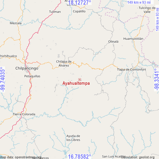
Ayahualtempa GPS coordinates[2]
17° 27' 28.008" North, 99° 2' 13.992" West
| Map corner | latitude | longitude |
|---|---|---|
| Upper-left | 18.12727°, | -99.74035° |
| Center: | 17.45778°, | -99.03722° |
| Lower-right: | 16.78582°, | -98.3341° |
| Map W x H: | 149.2×149.2 km | = 92.7×92.7mi |
| max Lat: | 32.7° ⇑83.5% North |
| Ayahualtempa: | 17.45778° |
| min Lat: | ⇓16.5% South 14.53588° |
| min Long | Ayahualtempa | max Long |
| -117.105° | -99.03722° | -86.73105° |
| W 49.7%⇐ | ⇒50.3% E |
Elevation
Elevation of Ayahualtempa is 1714 m = 5623 ft, and this is 460.3 m = 1510 ft above average elevation for this country.
| Max E: |
3497 m = 11473 ft | 40.8% |
| Ayahualtempa | 1714 m 5623 ft | |
| Avg. | 1253.7 m = 4113 ft | |
Min E: |
-1 m = -3 ft | 59.2% |
See also: Mexico elevation on elevation.city.
Geographical zone
Ayahualtempa is located in North Torrid zone (between Equator and Tropic of Cancer). Distance of this Northern Tropic circle is 664.8 km =413.1 mi to North.| Distance of | km | miles | from Ayahualtempa |
|---|---|---|---|
| North Pole | 8065.9 | 5011.9 | to North |
| Arctic Circle | 5460.1 | 3392.7 | to North |
| Tropic Cancer | 664.8 | 413.1 | to North |
| Equator | 1941.1 | 1206.1 | to South |


Nearby cities:
15 places around Ayahualtempa: (largest is in red/bold)
• Ahuixtla
8.1 km =5 mi,  0°
0°
• Alcozacán
8 km =5 mi,  310°
310°
• Apanguito
5.7 km =3.5 mi,  101°
101°
• Hueycantenango
1.7 km =1.1 mi,  126°
126°
• Ixcatla
5.6 km =3.5 mi, 134°
• Llano Grande
9.7 km =6 mi,  223°
223°
• Mazazontecomac
6.8 km =4.2 mi,  91°
91°
• Mexcalcingo
9 km =5.6 mi,  153°
153°
• Popocatzin
9.2 km =5.7 mi,  169°
169°
• San Jerónimo Palantla
9.5 km =5.9 mi,  325°
325°
• Tlachimaltepec
3.9 km =2.4 mi,  40°
40°
• Tlalchichiltipán Nuevo
7.7 km =4.8 mi, 148°
• Tlalixtlahuacán
9.3 km =5.8 mi,  289°
289°
• Tomactilicán
4.2 km =2.6 mi, 88°
• Zelocotitlán
7.4 km =4.6 mi,  260°
260°
Sources, notices
• [Note1] Compared only with cities in Mexico existing in our database
• [Src1] Map data: © OpenStreetMap contributors (CC-BY-SA)
• [Src2] Other city data from geonames.org with taken over terms of usage.
• [Src3] Geographical zone / Annual Mean Temperature by Robert A. Rohde @ Wikipedia
