Zopilostoc geodata
Zopilostoc (Guerrero) is a populated place; located in Mexico in America/Mexico_City (GMT-6) time zone. With population of 576 people, there are 14877 cities with bigger population in this country. Compared to other cities in Mexico, 81% of cities are located further ↑North; 63.9% of cities are located further →East and 53.2% of cities have lower elevation than Zopilostoc. Note1


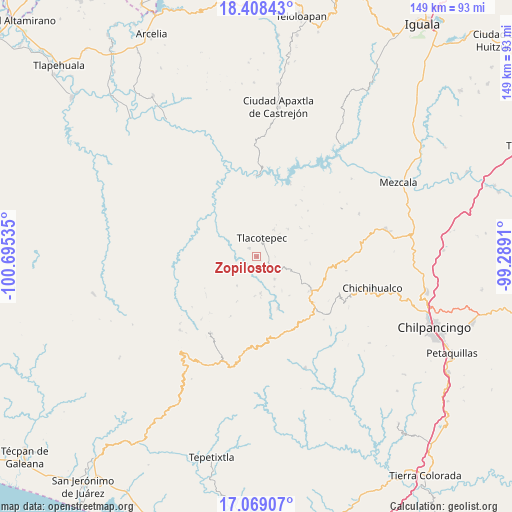
Zopilostoc GPS coordinates[2]
17° 44' 24" North, 99° 59' 31.992" West
| Map corner | latitude | longitude |
|---|---|---|
| Upper-left | 18.40843°, | -100.69535° |
| Center: | 17.74°, | -99.99222° |
| Lower-right: | 17.06907°, | -99.2891° |
| Map W x H: | 148.9×148.9 km | = 92.5×92.5mi |
| max Lat: | 32.7° ⇑81% North |
| Zopilostoc: | 17.74° |
| min Lat: | ⇓19% South 14.53588° |
| min Long | Zopilostoc | max Long |
| -117.105° | -99.99222° | -86.73105° |
| W 36.1%⇐ | ⇒63.9% E |
Elevation
Elevation of Zopilostoc is 1545 m = 5069 ft, and this is 291.3 m = 956 ft above average elevation for this country.
| Max E: |
3497 m = 11473 ft | 46.8% |
| Zopilostoc | 1545 m 5069 ft | |
| Avg. | 1253.7 m = 4113 ft | |
Min E: |
-1 m = -3 ft | 53.2% |
See also: Mexico elevation on elevation.city.
Geographical zone
Zopilostoc is located in North Torrid zone (between Equator and Tropic of Cancer). Distance of this Northern Tropic circle is 633.4 km =393.6 mi to North.| Distance of | km | miles | from Zopilostoc |
|---|---|---|---|
| North Pole | 8034.6 | 4992.5 | to North |
| Arctic Circle | 5428.7 | 3373.2 | to North |
| Tropic Cancer | 633.4 | 393.6 | to North |
| Equator | 1972.5 | 1225.7 | to South |


Nearby cities:
15 places around Zopilostoc: (largest is in red/bold)
• Chichiltepec
10.8 km =6.7 mi,  314°
314°
• Corral de Piedra
10.2 km =6.3 mi,  149°
149°
• Durazno del Rosario
14.1 km =8.8 mi,  277°
277°
• Huautla
17.2 km =10.7 mi,  316°
316°
• Huerta Vieja
8.3 km =5.2 mi,  142°
142°
• Izotepec
17.7 km =11 mi,  166°
166°
• La Ciénega
15.2 km =9.4 mi,  54°
54°
• La Venta
11.9 km =7.4 mi, 49°
• Los Hoyos
16.2 km =10.1 mi,  247°
247°
• Puerto General Nicolás Bravo (Filo de Caballos)
18.7 km =11.6 mi,  123°
123°
• Puerto del Varal
5.9 km =3.7 mi,  127°
127°
• Tlacotenco
8 km =5 mi,  55°
55°
• Tlacotepec
5.7 km =3.5 mi,  13°
13°
• Yextla
16.3 km =10.1 mi,  157°
157°
• Zompantle
3.3 km =2.1 mi, 315°
Sources, notices
• [Note1] Compared only with cities in Mexico existing in our database
• [Src1] Map data: © OpenStreetMap contributors (CC-BY-SA)
• [Src2] Other city data from geonames.org with taken over terms of usage.
• [Src3] Geographical zone / Annual Mean Temperature by Robert A. Rohde @ Wikipedia
