Huerta Vieja geodata
Huerta Vieja (Guerrero) is a populated place; located in Mexico in America/Mexico_City (GMT-6) time zone. With population of 737 people, there are 11858 cities with bigger population in this country. Compared to other cities in Mexico, 81.5% of cities are located further ↑North; 63.2% of cities are located further →East and 59.8% of cities have lower elevation than Huerta Vieja. Note1


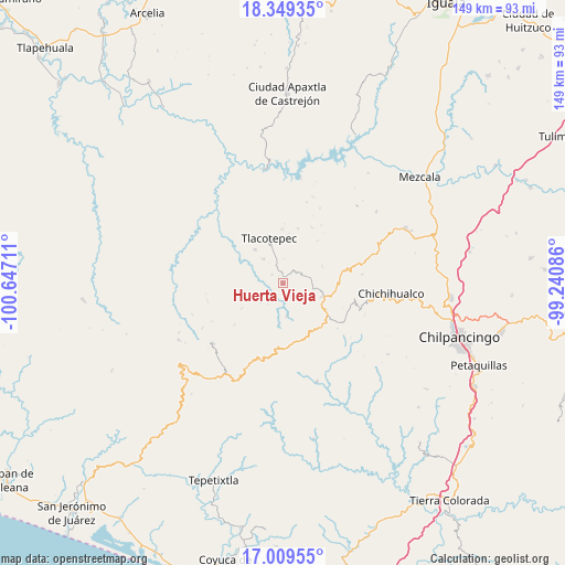
Huerta Vieja GPS coordinates[2]
17° 40' 50.52" North, 99° 56' 38.328" West
| Map corner | latitude | longitude |
|---|---|---|
| Upper-left | 18.34935°, | -100.64711° |
| Center: | 17.6807°, | -99.94398° |
| Lower-right: | 17.00955°, | -99.24086° |
| Map W x H: | 149×149 km | = 92.6×92.6mi |
| max Lat: | 32.7° ⇑81.5% North |
| Huerta Vieja: | 17.6807° |
| min Lat: | ⇓18.5% South 14.53588° |
| min Long | Huerta Vieja | max Long |
| -117.105° | -99.94398° | -86.73105° |
| W 36.8%⇐ | ⇒63.2% E |
Elevation
Elevation of Huerta Vieja is 1722 m = 5650 ft, and this is 468.3 m = 1536 ft above average elevation for this country.
| Max E: |
3497 m = 11473 ft | 40.2% |
| Huerta Vieja | 1722 m 5650 ft | |
| Avg. | 1253.7 m = 4113 ft | |
Min E: |
-1 m = -3 ft | 59.8% |
See also: Mexico elevation on elevation.city.
Geographical zone
Huerta Vieja is located in North Torrid zone (between Equator and Tropic of Cancer). Distance of this Northern Tropic circle is 640 km =397.7 mi to North.| Distance of | km | miles | from Huerta Vieja |
|---|---|---|---|
| North Pole | 8041.2 | 4996.6 | to North |
| Arctic Circle | 5435.3 | 3377.3 | to North |
| Tropic Cancer | 640 | 397.7 | to North |
| Equator | 1965.9 | 1221.6 | to South |


Nearby cities:
15 places around Huerta Vieja: (largest is in red/bold)
• Campo de Aviación
13.4 km =8.3 mi,  100°
100°
• Carrizal de Bravo
13.1 km =8.1 mi,  120°
120°
• Colonia General Heliodoro Castillo (Chicahuales)
19 km =11.8 mi,  171°
171°
• Corral de Piedra
2.2 km =1.4 mi,  178°
178°
• El Balzamar
18.5 km =11.5 mi,  129°
129°
• Izotepec
10.7 km =6.6 mi,  185°
185°
• La Ciénega
17 km =10.6 mi,  25°
25°
• La Venta
14.9 km =9.3 mi,  15°
15°
• Puerto General Nicolás Bravo (Filo de Caballos)
11.2 km =7 mi,  108°
108°
• Puerto del Varal
3.1 km =1.9 mi,  351°
351°
• Tlacotenco
11.3 km =7 mi,  7°
7°
• Tlacotepec
12.7 km =7.9 mi,  342°
342°
• Yextla
8.5 km =5.3 mi, 173°
• Zompantle
11.6 km =7.2 mi,  320°
320°
• Zopilostoc
8.3 km =5.2 mi, 322°
Sources, notices
• [Note1] Compared only with cities in Mexico existing in our database
• [Src1] Map data: © OpenStreetMap contributors (CC-BY-SA)
• [Src2] Other city data from geonames.org with taken over terms of usage.
• [Src3] Geographical zone / Annual Mean Temperature by Robert A. Rohde @ Wikipedia
