Tlacotenco geodata
Tlacotenco (Guerrero) is a populated place; located in Mexico in America/Mexico_City (GMT-6) time zone. With population of 552 people, there are 15449 cities with bigger population in this country. Compared to other cities in Mexico, 80.7% of cities are located further ↑North; 63% of cities are located further →East and 51.8% of cities have higher elevation than Tlacotenco. Note1


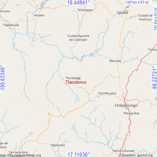
Tlacotenco GPS coordinates[2]
17° 46' 52.104" North, 99° 55' 49.188" West
| Map corner | latitude | longitude |
|---|---|---|
| Upper-left | 18.44941°, | -100.63346° |
| Center: | 17.78114°, | -99.93033° |
| Lower-right: | 17.11036°, | -99.22721° |
| Map W x H: | 148.9×148.9 km | = 92.5×92.5mi |
| max Lat: | 32.7° ⇑80.7% North |
| Tlacotenco: | 17.78114° |
| min Lat: | ⇓19.3% South 14.53588° |
| min Long | Tlacotenco | max Long |
| -117.105° | -99.93033° | -86.73105° |
| W 37%⇐ | ⇒63% E |
Elevation
Elevation of Tlacotenco is 1349 m = 4426 ft, and this is 95.3 m = 313 ft above average elevation for this country.
| Max E: |
3497 m = 11473 ft | 51.8% |
| Tlacotenco | 1349 m 4426 ft | |
| Avg. | 1253.7 m = 4113 ft | |
Min E: |
-1 m = -3 ft | 48.2% |
See also: Mexico elevation on elevation.city.
Geographical zone
Tlacotenco is located in North Torrid zone (between Equator and Tropic of Cancer). Distance of this Northern Tropic circle is 628.8 km =390.7 mi to North.| Distance of | km | miles | from Tlacotenco |
|---|---|---|---|
| North Pole | 8030 | 4989.6 | to North |
| Arctic Circle | 5424.1 | 3370.4 | to North |
| Tropic Cancer | 628.8 | 390.7 | to North |
| Equator | 1977.1 | 1228.5 | to South |


Nearby cities:
15 places around Tlacotenco: (largest is in red/bold)
• Acatlán del Río
17.4 km =10.8 mi,  10°
10°
• Campo de Aviación
18.1 km =11.2 mi,  139°
139°
• Chichiltepec
14.6 km =9.1 mi,  281°
281°
• Corral de Piedra
13.4 km =8.3 mi,  186°
186°
• Huautla
19.9 km =12.4 mi,  293°
293°
• Huerta Vieja
11.3 km =7 mi, 187°
• La Ciénega
7.2 km =4.5 mi,  54°
54°
• La Venta
4.1 km =2.5 mi,  38°
38°
• Las Vinatas
12.1 km =7.5 mi, 43°
• Puerto General Nicolás Bravo (Filo de Caballos)
17.4 km =10.8 mi,  148°
148°
• Puerto del Varal
8.3 km =5.2 mi, 193°
• Tlacotepec
5.3 km =3.3 mi, 280°
• Yextla
19.6 km =12.2 mi,  181°
181°
• Zompantle
9.1 km =5.7 mi,  255°
255°
• Zopilostoc
8 km =5 mi,  235°
235°
Sources, notices
• [Note1] Compared only with cities in Mexico existing in our database
• [Src1] Map data: © OpenStreetMap contributors (CC-BY-SA)
• [Src2] Other city data from geonames.org with taken over terms of usage.
• [Src3] Geographical zone / Annual Mean Temperature by Robert A. Rohde @ Wikipedia
