La Magdalena Cuaxixtla geodata
La Magdalena Cuaxixtla (Puebla) is a populated place; located in Mexico in America/Mexico_City (GMT-6) time zone. With population of 571 people, there are 14980 cities with bigger population in this country. Compared to other cities in Mexico, 67.5% of cities are located further ↑North; 64.1% of cities are located further ←West and 77.9% of cities have lower elevation than La Magdalena Cuaxixtla. Note1


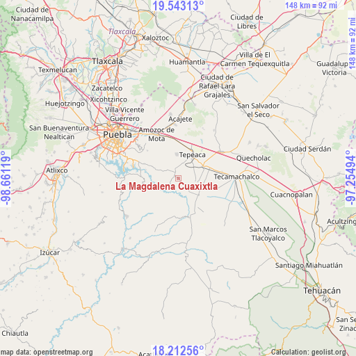
La Magdalena Cuaxixtla GPS coordinates[2]
18° 52' 45.012" North, 97° 57' 29.016" West
| Map corner | latitude | longitude |
|---|---|---|
| Upper-left | 19.54313°, | -98.66119° |
| Center: | 18.87917°, | -97.95806° |
| Lower-right: | 18.21256°, | -97.25494° |
| Map W x H: | 147.9×147.9 km | = 91.9×91.9mi |
| max Lat: | 32.7° ⇑67.5% North |
| La Magdalena Cuaxixtla: | 18.87917° |
| min Lat: | ⇓32.5% South 14.53588° |
| min Long | La Magdalena Cu | max Long |
| -117.105° | -97.95806° | -86.73105° |
| W 64.1%⇐ | ⇒35.9% E |
Elevation
Elevation of La Magdalena Cuaxixtla is 2086 m = 6844 ft, and this is 832.3 m = 2731 ft above average elevation for this country.
| Max E: |
3497 m = 11473 ft | 22.1% |
| La Magdalena Cuaxixtla | 2086 m 6844 ft | |
| Avg. | 1253.7 m = 4113 ft | |
Min E: |
-1 m = -3 ft | 77.9% |
See also: Mexico elevation on elevation.city.
Geographical zone
La Magdalena Cuaxixtla is located in North Torrid zone (between Equator and Tropic of Cancer). Distance of this Northern Tropic circle is 506.8 km =314.9 mi to North.| Distance of | km | miles | from La Magdalena Cuaxixtla |
|---|---|---|---|
| North Pole | 7907.9 | 4913.7 | to North |
| Arctic Circle | 5302 | 3294.5 | to North |
| Tropic Cancer | 506.8 | 314.9 | to North |
| Equator | 2099.2 | 1304.4 | to South |


Nearby cities:
15 places around La Magdalena Cuaxixtla: (largest is in red/bold)
• Actipan
8.7 km =5.4 mi,  42°
42°
• Ahuatepec
4.8 km =3 mi,  118°
118°
• Atoyatempan
8.1 km =5 mi,  145°
145°
• Concepción Cuautla
3.1 km =1.9 mi,  244°
244°
• Concepción Pardiñas
9.2 km =5.7 mi,  346°
346°
• La Trinidad Tianguismanalco
8 km =5 mi,  282°
282°
• Mixtla
7.2 km =4.5 mi,  66°
66°
• San Buenaventura
4.2 km =2.6 mi,  52°
52°
• San Jerónimo Almoloya
8.8 km =5.5 mi,  321°
321°
• San Luis Ajajalpan
6.8 km =4.2 mi,  21°
21°
• San Simón Coatepec
8.3 km =5.2 mi,  61°
61°
• Santa Ana Coapan
8.8 km =5.5 mi,  127°
127°
• Santa Cruz Ajajalpan
8.1 km =5 mi,  6°
6°
• Tecali
2.7 km =1.7 mi,  330°
330°
• Tlanepantla
7.7 km =4.8 mi,  103°
103°
Sources, notices
• [Note1] Compared only with cities in Mexico existing in our database
• [Src1] Map data: © OpenStreetMap contributors (CC-BY-SA)
• [Src2] Other city data from geonames.org with taken over terms of usage.
• [Src3] Geographical zone / Annual Mean Temperature by Robert A. Rohde @ Wikipedia
