San Luis Ajajalpan geodata
San Luis Ajajalpan (Puebla) is a populated place; located in Mexico in America/Mexico_City (GMT-6) time zone. With population of 2,380 people, there are 3709 cities with bigger population in this country. Compared to other cities in Mexico, 66.1% of cities are located further ↑North; 64.4% of cities are located further ←West and 81.6% of cities have lower elevation than San Luis Ajajalpan. Note1


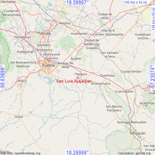
San Luis Ajajalpan GPS coordinates[2]
18° 56' 10.464" North, 97° 56' 1.896" West
| Map corner | latitude | longitude |
|---|---|---|
| Upper-left | 19.59997°, | -98.63699° |
| Center: | 18.93624°, | -97.93386° |
| Lower-right: | 18.26986°, | -97.23074° |
| Map W x H: | 147.9×147.9 km | = 91.9×91.9mi |
| max Lat: | 32.7° ⇑66.1% North |
| San Luis Ajajalpan: | 18.93624° |
| min Lat: | ⇓33.9% South 14.53588° |
| min Long | San Luis Ajajal | max Long |
| -117.105° | -97.93386° | -86.73105° |
| W 64.4%⇐ | ⇒35.6% E |
Elevation
Elevation of San Luis Ajajalpan is 2180 m = 7152 ft, and this is 926.3 m = 3039 ft above average elevation for this country.
| Max E: |
3497 m = 11473 ft | 18.4% |
| San Luis Ajajalpan | 2180 m 7152 ft | |
| Avg. | 1253.7 m = 4113 ft | |
Min E: |
-1 m = -3 ft | 81.6% |
See also: Mexico elevation on elevation.city.
Geographical zone
San Luis Ajajalpan is located in North Torrid zone (between Equator and Tropic of Cancer). Distance of this Northern Tropic circle is 500.4 km =310.9 mi to North.| Distance of | km | miles | from San Luis Ajajalpan |
|---|---|---|---|
| North Pole | 7901.5 | 4909.8 | to North |
| Arctic Circle | 5295.7 | 3290.6 | to North |
| Tropic Cancer | 500.4 | 310.9 | to North |
| Equator | 2105.5 | 1308.3 | to South |


Nearby cities:
15 places around San Luis Ajajalpan: (largest is in red/bold)
• Actipan
3.3 km =2.1 mi,  88°
88°
• Concepción Pardiñas
5.3 km =3.3 mi,  299°
299°
• Guadalupe Calderón
8.6 km =5.3 mi,  67°
67°
• La Magdalena Cuaxixtla
6.8 km =4.2 mi,  201°
201°
• Mixtla
5.3 km =3.3 mi,  130°
130°
• San Buenaventura
3.9 km =2.4 mi,  167°
167°
• San Hipólito
6.4 km =4 mi, 85°
• San Jerónimo Almoloya
8.1 km =5 mi,  273°
273°
• San José Carpinteros
6.9 km =4.3 mi,  19°
19°
• San Nicolás Zoyapetlayoca
7.3 km =4.5 mi,  100°
100°
• San Simón Coatepec
5.2 km =3.2 mi,  116°
116°
• Santa Cruz Ajajalpan
2.4 km =1.5 mi,  315°
315°
• Santiago Acatlán
6.3 km =3.9 mi,  0°
0°
• Tecali
5.5 km =3.4 mi,  224°
224°
• Tepeaca
4.9 km =3 mi,  46°
46°
Sources, notices
• [Note1] Compared only with cities in Mexico existing in our database
• [Src1] Map data: © OpenStreetMap contributors (CC-BY-SA)
• [Src2] Other city data from geonames.org with taken over terms of usage.
• [Src3] Geographical zone / Annual Mean Temperature by Robert A. Rohde @ Wikipedia
