Isla Mujeres geodata
Isla Mujeres (Quintana Roo) is a populated place; located in Mexico in America/Cancun (GMT-5) time zone. With population of 12,642 people, there are 770 cities with bigger population in this country. Compared to other cities in Mexico, 79.4% of cities are located further ↓South; 100% of cities are located further ←West and 100% of cities have higher elevation than Isla Mujeres. Note1


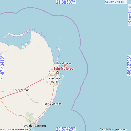
Isla Mujeres GPS coordinates[2]
21° 13' 52.104" North, 86° 43' 51.78" West
| Map corner | latitude | longitude |
|---|---|---|
| Upper-left | 21.88507°, | -87.43418° |
| Center: | 21.23114°, | -86.73105° |
| Lower-right: | 20.57429°, | -86.02793° |
| Map W x H: | 145.7×145.7 km | = 90.5×90.5mi |
| max Lat: | 32.7° ⇑20.6% North |
| Isla Mujeres: | 21.23114° |
| min Lat: | ⇓79.4% South 14.53588° |
| min Long | Isla Mujeres | max Long |
| -117.105° | -86.73105° | -86.73105° |
| W 100%⇐ | ⇒0% E |
Elevation
Elevation of Isla Mujeres is 1 m = 3 ft, and this is 1252.7 m = 4110 ft below average elevation for this country.
| Max E: |
3497 m = 11473 ft | 100% |
| Avg. | 1253.7 m = 4113 ft | |
| Isla Mujeres | 1 m = 3 ft | |
Min E: |
-1 m = -3 ft | 0% |
See also: Mexico elevation on elevation.city.
Geographical zone
Isla Mujeres is located in North Torrid zone (between Equator and Tropic of Cancer). Distance of this Northern Tropic circle is 245.2 km =152.4 mi to North.| Distance of | km | miles | from Isla Mujeres |
|---|---|---|---|
| North Pole | 7646.4 | 4751.3 | to North |
| Arctic Circle | 5040.5 | 3132 | to North |
| Tropic Cancer | 245.2 | 152.4 | to North |
| Equator | 2360.7 | 1466.9 | to South |


Nearby cities:
15 places around Isla Mujeres: (largest is in red/bold)
• Alfredo V. Bonfil
20 km =12.4 mi,  217°
217°
• Cancún
13.5 km =8.4 mi,  242°
242°
• Chiquilá
66.5 km =41.3 mi,  289°
289°
• Cozumel
84.2 km =52.3 mi,  195°
195°
• El Porvenir
32.7 km =20.3 mi, 238°
• El Tintal
85.1 km =52.9 mi, 243°
• Isla Holbox
74.5 km =46.3 mi,  295°
295°
• Kantunilkín
79.6 km =49.5 mi,  259°
259°
• Las Fincas
83.7 km =52 mi,  193°
193°
• Leona Vicario
55.8 km =34.7 mi, 241°
• Playa del Carmen
76.3 km =47.4 mi,  208°
208°
• San Angel
72.6 km =45.1 mi,  270°
270°
• Solferino
73.5 km =45.7 mi,  280°
280°
• Vicente Guerrero
83.6 km =51.9 mi,  250°
250°
• Zona Urbana Ejido Isla Mujeres
12.7 km =7.9 mi, 266°
Sources, notices
• [Note1] Compared only with cities in Mexico existing in our database
• [Src1] Map data: © OpenStreetMap contributors (CC-BY-SA)
• [Src2] Other city data from geonames.org with taken over terms of usage.
• [Src3] Geographical zone / Annual Mean Temperature by Robert A. Rohde @ Wikipedia
