Arena de Hidalgo geodata
Arena de Hidalgo (Tabasco) is a populated place; located in Mexico in America/Mexico_City (GMT-6) time zone. With population of 1,270 people, there are 6821 cities with bigger population in this country. Compared to other cities in Mexico, 83.5% of cities are located further ↑North; 96.2% of cities are located further ←West and 84.5% of cities have higher elevation than Arena de Hidalgo. Note1


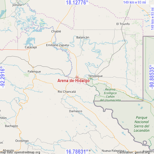
Arena de Hidalgo GPS coordinates[2]
17° 27' 29.772" North, 91° 35' 18.492" West
| Map corner | latitude | longitude |
|---|---|---|
| Upper-left | 18.12776°, | -92.2916° |
| Center: | 17.45827°, | -91.58847° |
| Lower-right: | 16.78631°, | -90.88535° |
| Map W x H: | 149.2×149.2 km | = 92.7×92.7mi |
| max Lat: | 32.7° ⇑83.5% North |
| Arena de Hidalgo: | 17.45827° |
| min Lat: | ⇓16.5% South 14.53588° |
| min Long | Arena de Hidalg | max Long |
| -117.105° | -91.58847° | -86.73105° |
| W 96.2%⇐ | ⇒3.8% E |
Elevation
Elevation of Arena de Hidalgo is 48 m = 157 ft, and this is 1205.7 m = 3956 ft below average elevation for this country.
| Max E: |
3497 m = 11473 ft | 84.5% |
| Avg. | 1253.7 m = 4113 ft | |
| Arena de Hidalgo | 48 m = 157 ft | |
Min E: |
-1 m = -3 ft | 15.5% |
See also: Mexico elevation on elevation.city.
Geographical zone
Arena de Hidalgo is located in North Torrid zone (between Equator and Tropic of Cancer). Distance of this Northern Tropic circle is 664.7 km =413 mi to North.| Distance of | km | miles | from Arena de Hidalgo |
|---|---|---|---|
| North Pole | 8065.9 | 5011.9 | to North |
| Arctic Circle | 5460 | 3392.7 | to North |
| Tropic Cancer | 664.7 | 413 | to North |
| Equator | 1941.2 | 1206.2 | to South |


Nearby cities:
15 places around Arena de Hidalgo: (largest is in red/bold)
• Benito Juárez Centro
19.7 km =12.2 mi,  324°
324°
• Chacama
22.6 km =14 mi,  352°
352°
• El Clavo
9.3 km =5.8 mi,  208°
208°
• El Desierto
11.2 km =7 mi,  255°
255°
• El Edén
20.8 km =12.9 mi,  171°
171°
• Estapilla
21.7 km =13.5 mi,  63°
63°
• General Luis Felipe Domínguez Suárez
22.7 km =14.1 mi,  13°
13°
• La Isla
11.2 km =7 mi,  77°
77°
• La Reforma de Ocampo
19.6 km =12.2 mi, 214°
• Lázaro Cárdenas
11.5 km =7.1 mi,  160°
160°
• Río Chancalá
17.1 km =10.6 mi,  216°
216°
• San Juan Chancalaíto
19.4 km =12.1 mi,  228°
228°
• San Martín Chamizal
21.6 km =13.4 mi,  185°
185°
• Tenosique
17.6 km =10.9 mi, 84°
• Usumacinta
14.6 km =9.1 mi,  43°
43°
Sources, notices
• [Note1] Compared only with cities in Mexico existing in our database
• [Src1] Map data: © OpenStreetMap contributors (CC-BY-SA)
• [Src2] Other city data from geonames.org with taken over terms of usage.
• [Src3] Geographical zone / Annual Mean Temperature by Robert A. Rohde @ Wikipedia
