Paka geodata
Paka (Terengganu) is a populated place; located in Malaysia in Asia/Kuala_Lumpur (GMT+8) time zone. With population of 21,044 people, there are 115 cities with bigger population in this country. Compared to other cities in Malaysia, 60.1% of cities are located further ↓South; 74.7% of cities are located further ←West and 70.8% of cities have higher elevation than Paka. Note1


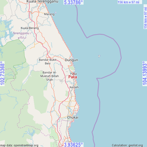
Paka GPS coordinates[2]
4° 38' 14.64" North, 103° 26' 12.48" East
| Map corner | latitude | longitude |
|---|---|---|
| Upper-left | 5.33786°, | 102.73368° |
| Center: | 4.6374°, | 103.4368° |
| Lower-right: | 3.93625°, | 104.13993° |
| Map W x H: | 155.8×155.8 km | = 96.8×96.8mi |
| max Lat: | 6.88732° ⇑39.9% North |
| Paka: | 4.6374° |
| min Lat: | ⇓60.1% South 1.24722° |
| min Long | Paka | max Long |
| 99.68252° | 103.4368° | 118.61119° |
| W 74.7%⇐ | ⇒25.3% E |
Elevation
Elevation of Paka is 9 m = 30 ft, and this is 35.7 m = 117 ft below average elevation for this country.
| Max E: |
1488 m = 4882 ft | 70.8% |
| Avg. | 44.7 m = 147 ft | |
| Paka | 9 m = 30 ft | |
Min E: |
0 m = 0 ft | 29.2% |
See also: Malaysia elevation on elevation.city.
Geographical zone
Paka is located in North Torrid zone (between Equator and Tropic of Cancer). Distance of Equator is 515.6 km =320.4 mi to South.| Distance of | km | miles | from Paka |
|---|---|---|---|
| North Pole | 9491.4 | 5897.7 | to North |
| Arctic Circle | 6885.5 | 4278.5 | to North |
| Tropic Cancer | 2090.3 | 1298.9 | to North |
| Equator | 515.6 | 320.4 | to South |


Nearby cities:
15 places around Paka: (largest is in red/bold)
• Cukai
43.1 km =26.8 mi,  182°
182°
• Gua Musang
165 km =102.5 mi,  279°
279°
• Jerantut
142.4 km =88.5 mi,  236°
236°
• Jertih
160.8 km =99.9 mi,  319°
319°
• Kampung Kuala Besut
165.2 km =102.7 mi, 323°
• Kertih
13.8 km =8.6 mi,  174°
174°
• Kuala Besut
164.9 km =102.5 mi, 323°
• Kuala Lipis
162.1 km =100.7 mi,  251°
251°
• Kuala Terengganu
83.7 km =52 mi,  336°
336°
• Kuantan
93.1 km =57.8 mi,  187°
187°
• Marang
68.2 km =42.4 mi, 337°
• Mentekab
176 km =109.4 mi,  223°
223°
• Pekan
128.4 km =79.8 mi, 181°
• Pulai Chondong
191.4 km =118.9 mi, 315°
• Temerluh
173.8 km =108 mi, 220°
Sources, notices
• [Note1] Compared only with cities in Malaysia existing in our database
• [Src1] Map data: © OpenStreetMap contributors (CC-BY-SA)
• [Src2] Other city data from geonames.org with taken over terms of usage.
• [Src3] Geographical zone / Annual Mean Temperature by Robert A. Rohde @ Wikipedia
