Kertih geodata
Kertih (Terengganu) is a populated place; located in Malaysia in Asia/Kuala_Lumpur (GMT+8) time zone. With population of 24,401 people, there are 104 cities with bigger population in this country. Compared to other cities in Malaysia, 59% of cities are located further ↓South; 75.3% of cities are located further ←West and 94.4% of cities have higher elevation than Kertih. Note1


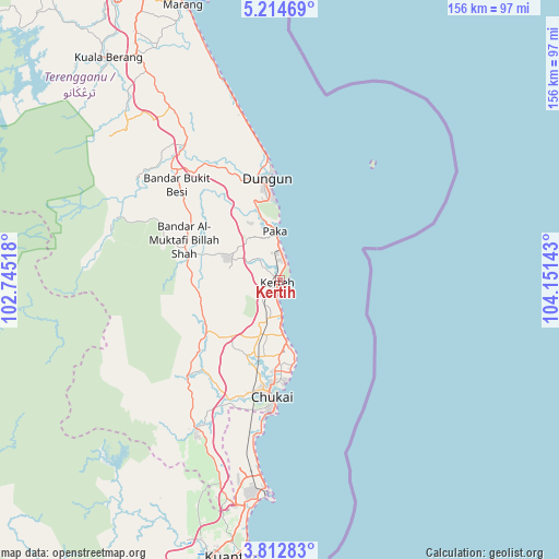
Kertih GPS coordinates[2]
4° 30' 50.76" North, 103° 26' 53.88" East
| Map corner | latitude | longitude |
|---|---|---|
| Upper-left | 5.21469°, | 102.74518° |
| Center: | 4.5141°, | 103.4483° |
| Lower-right: | 3.81283°, | 104.15143° |
| Map W x H: | 155.9×155.9 km | = 96.9×96.9mi |
| max Lat: | 6.88732° ⇑41% North |
| Kertih: | 4.5141° |
| min Lat: | ⇓59% South 1.24722° |
| min Long | Kertih | max Long |
| 99.68252° | 103.4483° | 118.61119° |
| W 75.3%⇐ | ⇒24.7% E |
Elevation
Elevation of Kertih is 5 m = 16 ft, and this is 39.7 m = 130 ft below average elevation for this country.
| Max E: |
1488 m = 4882 ft | 94.4% |
| Avg. | 44.7 m = 147 ft | |
| Kertih | 5 m = 16 ft | |
Min E: |
0 m = 0 ft | 5.6% |
See also: Malaysia elevation on elevation.city.
Geographical zone
Kertih is located in North Torrid zone (between Equator and Tropic of Cancer). Distance of Equator is 501.9 km =311.9 mi to South.| Distance of | km | miles | from Kertih |
|---|---|---|---|
| North Pole | 9505.1 | 5906.2 | to North |
| Arctic Circle | 6899.3 | 4287 | to North |
| Tropic Cancer | 2104 | 1307.4 | to North |
| Equator | 501.9 | 311.9 | to South |


Nearby cities:
15 places around Kertih: (largest is in red/bold)
• Cukai
29.6 km =18.4 mi,  186°
186°
• Gua Musang
169.1 km =105.1 mi,  284°
284°
• Jerantut
136.5 km =84.8 mi,  241°
241°
• Jertih
172.2 km =107 mi,  321°
321°
• Kampung Kuala Besut
177.2 km =110.1 mi,  325°
325°
• Kuala Besut
176.9 km =109.9 mi, 326°
• Kuala Lipis
159.7 km =99.2 mi,  256°
256°
• Kuala Terengganu
96.9 km =60.2 mi,  339°
339°
• Kuantan
79.7 km =49.5 mi, 189°
• Marang
81.4 km =50.6 mi, 340°
• Mentekab
167.2 km =103.9 mi,  226°
226°
• Paka
13.8 km =8.6 mi,  354°
354°
• Pekan
114.7 km =71.3 mi,  182°
182°
• Raub
194 km =120.5 mi,  245°
245°
• Temerluh
164.5 km =102.2 mi,  224°
224°
Sources, notices
• [Note1] Compared only with cities in Malaysia existing in our database
• [Src1] Map data: © OpenStreetMap contributors (CC-BY-SA)
• [Src2] Other city data from geonames.org with taken over terms of usage.
• [Src3] Geographical zone / Annual Mean Temperature by Robert A. Rohde @ Wikipedia
