Kuantan geodata
Kuantan (Pahang) is a seat of a first-order administrative division; located in Malaysia in Asia/Kuala_Lumpur (GMT+8) time zone. With population of 366,229 people, there are 13 cities with bigger population in this country. Compared to other cities in Malaysia, 50% of cities are located further ↓South; 72.5% of cities are located further ←West and 56.2% of cities have higher elevation than Kuantan. Note1


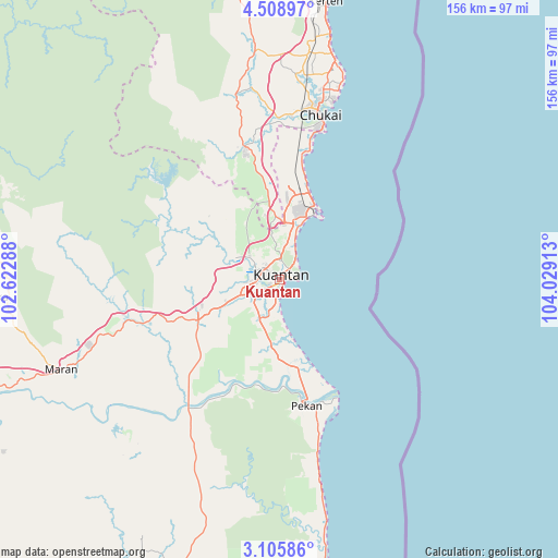
Kuantan GPS coordinates[2]
3° 48' 27.72" North, 103° 19' 33.6" East
| Map corner | latitude | longitude |
|---|---|---|
| Upper-left | 4.50897°, | 102.62288° |
| Center: | 3.8077°, | 103.326° |
| Lower-right: | 3.10586°, | 104.02913° |
| Map W x H: | 156×156 km | = 96.9×96.9mi |
| max Lat: | 6.88732° ⇑50% North |
| Kuantan: | 3.8077° |
| min Lat: | ⇓50% South 1.24722° |
| min Long | Kuantan | max Long |
| 99.68252° | 103.326° | 118.61119° |
| W 72.5%⇐ | ⇒27.5% E |
Elevation
Elevation of Kuantan is 12 m = 39 ft, and this is 32.7 m = 107 ft below average elevation for this country.
| Max E: |
1488 m = 4882 ft | 56.2% |
| Avg. | 44.7 m = 147 ft | |
| Kuantan | 12 m = 39 ft | |
Min E: |
0 m = 0 ft | 43.8% |
See also: Kuantan elevation on elevation.city.
Geographical zone
Kuantan is located in North Torrid zone (between Equator and Tropic of Cancer). Distance of Equator is 423.4 km =263.1 mi to South.| Distance of | km | miles | from Kuantan |
|---|---|---|---|
| North Pole | 9583.7 | 5955 | to North |
| Arctic Circle | 6977.8 | 4335.8 | to North |
| Tropic Cancer | 2182.5 | 1356.1 | to North |
| Equator | 423.4 | 263.1 | to South |


Nearby cities:
15 places around Kuantan: (largest is in red/bold)
• Bahau
151 km =93.8 mi,  222°
222°
• Bentong Town
160.4 km =99.7 mi,  258°
258°
• Buloh Kasap
152.8 km =94.9 mi,  204°
204°
• Cukai
50.2 km =31.2 mi,  11°
11°
• Jerantut
107.8 km =67 mi,  277°
277°
• Kampung Tekek
144 km =89.5 mi,  140°
140°
• Kertih
79.7 km =49.5 mi, 9°
• Kuala Lipis
147.9 km =91.9 mi,  286°
286°
• Labis
161.8 km =100.5 mi,  192°
192°
• Marang
156 km =96.9 mi,  355°
355°
• Mentekab
114.2 km =71 mi,  251°
251°
• Paka
93.1 km =57.8 mi, 7°
• Pekan
37 km =23 mi,  167°
167°
• Segamat
154.5 km =96 mi, 201°
• Temerluh
108.3 km =67.3 mi, 248°
Sources, notices
• [Note1] Compared only with cities in Malaysia existing in our database
• [Src1] Map data: © OpenStreetMap contributors (CC-BY-SA)
• [Src2] Other city data from geonames.org with taken over terms of usage.
• [Src3] Geographical zone / Annual Mean Temperature by Robert A. Rohde @ Wikipedia
