Mont-Dore geodata
Mont-Dore (South Province) is a populated place; located in New Caledonia in Pacific/Noumea (GMT+11) time zone. With population of 24,680 people, there is 1 city with bigger population in this country. Compared to other cities in New Caledonia, 93.3% of cities are located further ↑North; 86.7% of cities are located further ←West and 70% of cities have higher elevation than Mont-Dore. Note1


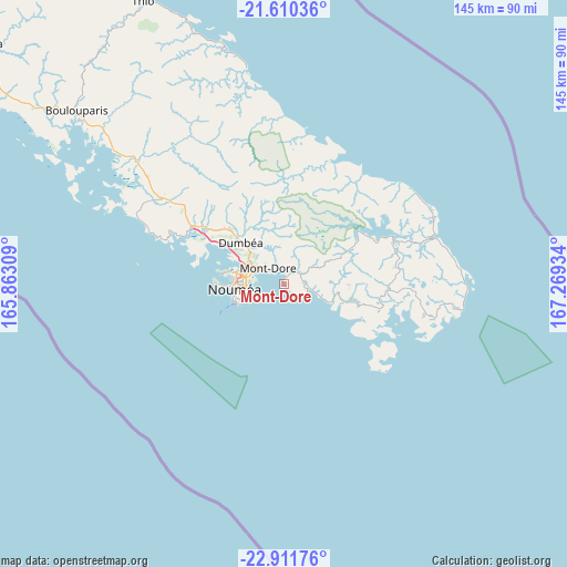
Mont-Dore GPS coordinates[2]
22° 15' 45.252" South, 166° 33' 58.356" East
| Map corner | latitude | longitude |
|---|---|---|
| Upper-left | -21.61036°, | 165.86309° |
| Center: | -22.26257°, | 166.56621° |
| Lower-right: | -22.91176°, | 167.26934° |
| Map W x H: | 144.7×144.7 km | = 89.9×89.9mi |
| max Lat: | -19.71161° ⇑93.3% North |
| Mont-Dore: | -22.26257° |
| min Lat: | ⇓6.7% South -22.66645° |
| min Long | Mont-Dore | max Long |
| 163.64702° | 166.56621° | 167.88019° |
| W 86.7%⇐ | ⇒13.3% E |
Elevation
Elevation of Mont-Dore is 11 m = 36 ft, and this is 32.3 m = 106 ft below average elevation for this country.
| Max E: |
275 m = 902 ft | 70% |
| Avg. | 43.3 m = 142 ft | |
| Mont-Dore | 11 m = 36 ft | |
Min E: |
1 m = 3 ft | 30% |
See also: New Caledonia elevation on elevation.city.
Geographical zone
Mont-Dore is located in South Torrid zone (between Equator and Tropic of Capricorn). Distance of this Southern Tropic circle is 130.6 km =81.2 mi to South.| Distance of | km | miles | from Mont-Dore |
|---|---|---|---|
| Equator | 2475.4 | 1538.1 | to North |
| Tropic Capricorn | 130.6 | 81.2 | to South |
| Antarctic Circle | 4925.8 | 3060.7 | to South |
| South Pole | 7531.7 | 4680 | to South |


Nearby cities:
15 places around Mont-Dore: (largest is in red/bold)
• Bouloupari
69.3 km =43.1 mi,  309°
309°
• Bourail
134.7 km =83.7 mi, 305°
• Canala
103 km =64 mi,  321°
321°
• Dumbéa
16.2 km =10.1 mi, 316°
• Houaïlou
146.5 km =91 mi, 317°
• La Foa
97.8 km =60.8 mi, 308°
• Moindou
110.5 km =68.7 mi,  304°
304°
• Nouméa
12.1 km =7.5 mi,  263°
263°
• Païta
26 km =16.2 mi, 304°
• Sarraméa
100.5 km =62.4 mi, 312°
• Tadine
157.1 km =97.6 mi,  59°
59°
• Thio
80.4 km =50 mi,  333°
333°
• Vao
105.6 km =65.6 mi,  115°
115°
• Wé
166.1 km =103.2 mi,  25°
25°
• Yaté-Barrage
35 km =21.7 mi,  69°
69°
Sources, notices
• [Note1] Compared only with cities in New Caledonia existing in our database
• [Src1] Map data: © OpenStreetMap contributors (CC-BY-SA)
• [Src2] Other city data from geonames.org with taken over terms of usage.
• [Src3] Geographical zone / Annual Mean Temperature by Robert A. Rohde @ Wikipedia
