Bourail geodata
Bourail (South Province) is a populated place; located in New Caledonia in Pacific/Noumea (GMT+11) time zone. With population of 4,826 people, there are 7 cities with bigger population in this country. Compared to other cities in New Caledonia, 63.3% of cities are located further ↑North; 53.3% of cities are located further →East and 80% of cities have higher elevation than Bourail. Note1


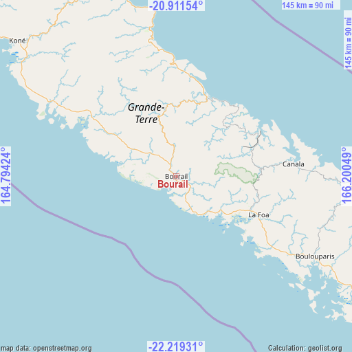
Bourail GPS coordinates[2]
21° 34' 0.84" South, 165° 29' 50.496" East
| Map corner | latitude | longitude |
|---|---|---|
| Upper-left | -20.91154°, | 164.79424° |
| Center: | -21.5669°, | 165.49736° |
| Lower-right: | -22.21931°, | 166.20049° |
| Map W x H: | 145.4×145.4 km | = 90.3×90.3mi |
| max Lat: | -19.71161° ⇑63.3% North |
| Bourail: | -21.5669° |
| min Lat: | ⇓36.7% South -22.66645° |
| min Long | Bourail | max Long |
| 163.64702° | 165.49736° | 167.88019° |
| W 46.7%⇐ | ⇒53.3% E |
Elevation
Elevation of Bourail is 9 m = 30 ft, and this is 34.3 m = 113 ft below average elevation for this country.
| Max E: |
275 m = 902 ft | 80% |
| Avg. | 43.3 m = 142 ft | |
| Bourail | 9 m = 30 ft | |
Min E: |
1 m = 3 ft | 20% |
See also: New Caledonia elevation on elevation.city.
Geographical zone
Bourail is located in South Torrid zone (between Equator and Tropic of Capricorn). Distance of this Southern Tropic circle is 207.9 km =129.2 mi to South.| Distance of | km | miles | from Bourail |
|---|---|---|---|
| Equator | 2398 | 1490 | to North |
| Tropic Capricorn | 207.9 | 129.2 | to South |
| Antarctic Circle | 5003.2 | 3108.8 | to South |
| South Pole | 7609 | 4728 | to South |


Nearby cities:
15 places around Bourail: (largest is in red/bold)
• Bouloupari
66 km =41 mi,  119°
119°
• Canala
47 km =29.2 mi,  85°
85°
• Houaïlou
33.9 km =21.1 mi,  21°
21°
• Koné
86.4 km =53.7 mi,  310°
310°
• La Foa
37.7 km =23.4 mi, 115°
• Moindou
24.3 km =15.1 mi,  127°
127°
• Païta
108.7 km =67.5 mi, 125°
• Poindimié
72.5 km =45 mi,  346°
346°
• Ponérihouen
54.7 km =34 mi, 349°
• Pouembout
78.4 km =48.7 mi, 307°
• Poya
43.3 km =26.9 mi,  303°
303°
• Sarraméa
37.6 km =23.4 mi,  104°
104°
• Thio
74.6 km =46.4 mi, 94°
• Touho
90 km =55.9 mi,  343°
343°
• Voh
106.2 km =66 mi, 308°
Sources, notices
• [Note1] Compared only with cities in New Caledonia existing in our database
• [Src1] Map data: © OpenStreetMap contributors (CC-BY-SA)
• [Src2] Other city data from geonames.org with taken over terms of usage.
• [Src3] Geographical zone / Annual Mean Temperature by Robert A. Rohde @ Wikipedia
