La Foa geodata
La Foa (South Province) is a seat of a first-order administrative division; located in New Caledonia in Pacific/Noumea (GMT+11) time zone. With population of 2,947 people, there are 13 cities with bigger population in this country. Compared to other cities in New Caledonia, 76.7% of cities are located further ↑North; 56.7% of cities are located further ←West and 70% of cities have lower elevation than La Foa. Note1


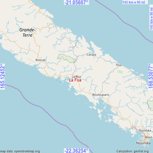
La Foa GPS coordinates[2]
21° 42' 38.844" South, 165° 49' 39.504" East
| Map corner | latitude | longitude |
|---|---|---|
| Upper-left | -21.05607°, | 165.12452° |
| Center: | -21.71079°, | 165.82764° |
| Lower-right: | -22.36254°, | 166.53077° |
| Map W x H: | 145.3×145.3 km | = 90.3×90.3mi |
| max Lat: | -19.71161° ⇑76.7% North |
| La Foa: | -21.71079° |
| min Lat: | ⇓23.3% South -22.66645° |
| min Long | La Foa | max Long |
| 163.64702° | 165.82764° | 167.88019° |
| W 56.7%⇐ | ⇒43.3% E |
Elevation
Elevation of La Foa is 24 m = 79 ft, and this is 19.3 m = 63 ft below average elevation for this country.
| Max E: |
275 m = 902 ft | 30% |
| Avg. | 43.3 m = 142 ft | |
| La Foa | 24 m = 79 ft | |
Min E: |
1 m = 3 ft | 70% |
See also: New Caledonia elevation on elevation.city.
Geographical zone
La Foa is located in South Torrid zone (between Equator and Tropic of Capricorn). Distance of this Southern Tropic circle is 191.9 km =119.2 mi to South.| Distance of | km | miles | from La Foa |
|---|---|---|---|
| Equator | 2414 | 1500 | to North |
| Tropic Capricorn | 191.9 | 119.2 | to South |
| Antarctic Circle | 4987.2 | 3098.9 | to South |
| South Pole | 7593 | 4718.1 | to South |


Nearby cities:
15 places around La Foa: (largest is in red/bold)
• Bouloupari
28.6 km =17.8 mi,  126°
126°
• Bourail
37.7 km =23.4 mi,  295°
295°
• Canala
23.4 km =14.5 mi,  32°
32°
• Dumbéa
81.8 km =50.8 mi, 127°
• Houaïlou
52.3 km =32.5 mi,  335°
335°
• Moindou
15 km =9.3 mi,  274°
274°
• Mont-Dore
97.8 km =60.8 mi, 128°
• Nouméa
89.6 km =55.7 mi, 134°
• Païta
71.9 km =44.7 mi, 130°
• Poindimié
100.5 km =62.4 mi,  329°
329°
• Ponérihouen
82.6 km =51.3 mi, 327°
• Pouembout
115.5 km =71.8 mi, 303°
• Poya
80.8 km =50.2 mi, 299°
• Sarraméa
7.1 km =4.4 mi,  18°
18°
• Thio
41.5 km =25.8 mi,  75°
75°
Sources, notices
• [Note1] Compared only with cities in New Caledonia existing in our database
• [Src1] Map data: © OpenStreetMap contributors (CC-BY-SA)
• [Src2] Other city data from geonames.org with taken over terms of usage.
• [Src3] Geographical zone / Annual Mean Temperature by Robert A. Rohde @ Wikipedia
