Canala geodata
Canala (North Province) is a populated place; located in New Caledonia in Pacific/Noumea (GMT+11) time zone. With population of 3,538 people, there are 11 cities with bigger population in this country. Compared to other cities in New Caledonia, 56.7% of cities are located further ↑North; 63.3% of cities are located further ←West and 83.3% of cities have lower elevation than Canala. Note1


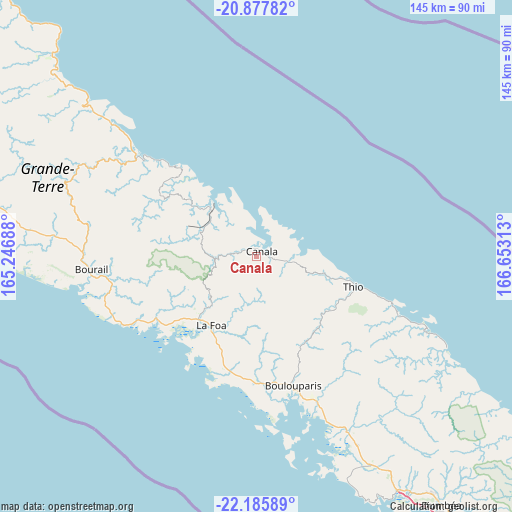
Canala GPS coordinates[2]
21° 31' 59.988" South, 165° 57' 0" East
| Map corner | latitude | longitude |
|---|---|---|
| Upper-left | -20.87782°, | 165.24688° |
| Center: | -21.53333°, | 165.95° |
| Lower-right: | -22.18589°, | 166.65313° |
| Map W x H: | 145.4×145.4 km | = 90.3×90.3mi |
| max Lat: | -19.71161° ⇑56.7% North |
| Canala: | -21.53333° |
| min Lat: | ⇓43.3% South -22.66645° |
| min Long | Canala | max Long |
| 163.64702° | 165.95° | 167.88019° |
| W 63.3%⇐ | ⇒36.7% E |
Elevation
Elevation of Canala is 108 m = 354 ft, and this is 64.7 m = 212 ft above average elevation for this country.
| Max E: |
275 m = 902 ft | 16.7% |
| Canala | 108 m 354 ft | |
| Avg. | 43.3 m = 142 ft | |
Min E: |
1 m = 3 ft | 83.3% |
See also: New Caledonia elevation on elevation.city.
Geographical zone
Canala is located in South Torrid zone (between Equator and Tropic of Capricorn). Distance of this Southern Tropic circle is 211.6 km =131.5 mi to South.| Distance of | km | miles | from Canala |
|---|---|---|---|
| Equator | 2394.3 | 1487.7 | to North |
| Tropic Capricorn | 211.6 | 131.5 | to South |
| Antarctic Circle | 5006.9 | 3111.1 | to South |
| South Pole | 7612.8 | 4730.4 | to South |


Nearby cities:
15 places around Canala: (largest is in red/bold)
• Bouloupari
38 km =23.6 mi,  164°
164°
• Bourail
47 km =29.2 mi,  265°
265°
• Dumbéa
86.9 km =54 mi,  142°
142°
• Houaïlou
44.3 km =27.5 mi,  308°
308°
• La Foa
23.4 km =14.5 mi,  212°
212°
• Moindou
33.2 km =20.6 mi,  236°
236°
• Mont-Dore
103 km =64 mi, 141°
• Nouméa
97.1 km =60.3 mi,  148°
148°
• Païta
78.6 km =48.8 mi, 147°
• Poindimié
92.4 km =57.4 mi,  316°
316°
• Ponérihouen
75.8 km =47.1 mi, 311°
• Poya
85.3 km =53 mi,  283°
283°
• Sarraméa
16.6 km =10.3 mi,  218°
218°
• Thio
29.1 km =18.1 mi,  108°
108°
• Touho
109.9 km =68.3 mi, 318°
Sources, notices
• [Note1] Compared only with cities in New Caledonia existing in our database
• [Src1] Map data: © OpenStreetMap contributors (CC-BY-SA)
• [Src2] Other city data from geonames.org with taken over terms of usage.
• [Src3] Geographical zone / Annual Mean Temperature by Robert A. Rohde @ Wikipedia
