Moindou geodata
Moindou (South Province) is a populated place; located in New Caledonia in Pacific/Noumea (GMT+11) time zone. With population of 609 people, there are 30 cities with bigger population in this country. Compared to other cities in New Caledonia, 73.3% of cities are located further ↑North; 53.3% of cities are located further ←West and 93.3% of cities have higher elevation than Moindou. Note1


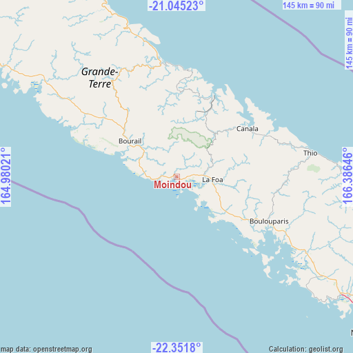
Moindou GPS coordinates[2]
21° 42' 0" South, 165° 40' 59.988" East
| Map corner | latitude | longitude |
|---|---|---|
| Upper-left | -21.04523°, | 164.98021° |
| Center: | -21.7°, | 165.68333° |
| Lower-right: | -22.3518°, | 166.38646° |
| Map W x H: | 145.3×145.3 km | = 90.3×90.3mi |
| max Lat: | -19.71161° ⇑73.3% North |
| Moindou: | -21.7° |
| min Lat: | ⇓26.7% South -22.66645° |
| min Long | Moindou | max Long |
| 163.64702° | 165.68333° | 167.88019° |
| W 53.3%⇐ | ⇒46.7% E |
Elevation
Elevation of Moindou is 4 m = 13 ft, and this is 39.3 m = 129 ft below average elevation for this country.
| Max E: |
275 m = 902 ft | 93.3% |
| Avg. | 43.3 m = 142 ft | |
| Moindou | 4 m = 13 ft | |
Min E: |
1 m = 3 ft | 6.7% |
See also: New Caledonia elevation on elevation.city.
Geographical zone
Moindou is located in South Torrid zone (between Equator and Tropic of Capricorn). Distance of this Southern Tropic circle is 193.1 km =120 mi to South.| Distance of | km | miles | from Moindou |
|---|---|---|---|
| Equator | 2412.8 | 1499.2 | to North |
| Tropic Capricorn | 193.1 | 120 | to South |
| Antarctic Circle | 4988.4 | 3099.6 | to South |
| South Pole | 7594.2 | 4718.8 | to South |


Nearby cities:
15 places around Moindou: (largest is in red/bold)
• Bouloupari
42.1 km =26.2 mi,  115°
115°
• Bourail
24.3 km =15.1 mi,  307°
307°
• Canala
33.2 km =20.6 mi,  56°
56°
• Dumbéa
94.7 km =58.8 mi, 122°
• Houaïlou
46.8 km =29.1 mi,  351°
351°
• La Foa
15 km =9.3 mi,  94°
94°
• Mont-Dore
110.5 km =68.7 mi, 124°
• Nouméa
101.5 km =63.1 mi,  128°
128°
• Païta
84.4 km =52.4 mi, 124°
• Poindimié
92.6 km =57.5 mi,  336°
336°
• Ponérihouen
74.6 km =46.4 mi, 336°
• Pouembout
102.7 km =63.8 mi, 307°
• Poya
67.5 km =41.9 mi, 305°
• Sarraméa
18.1 km =11.2 mi,  72°
72°
• Thio
55.9 km =34.7 mi,  80°
80°
Sources, notices
• [Note1] Compared only with cities in New Caledonia existing in our database
• [Src1] Map data: © OpenStreetMap contributors (CC-BY-SA)
• [Src2] Other city data from geonames.org with taken over terms of usage.
• [Src3] Geographical zone / Annual Mean Temperature by Robert A. Rohde @ Wikipedia
