Poindimié geodata
Poindimié (North Province) is a populated place; located in New Caledonia in Pacific/Noumea (GMT+11) time zone. With population of 4,885 people, there are 6 cities with bigger population in this country. Compared to other cities in New Caledonia, 66.7% of cities are located further ↓South; 60% of cities are located further →East and 73.3% of cities have lower elevation than Poindimié. Note1


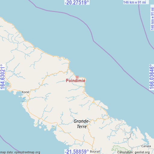
Poindimié GPS coordinates[2]
20° 55' 59.988" South, 165° 19' 59.988" East
| Map corner | latitude | longitude |
|---|---|---|
| Upper-left | -20.27519°, | 164.63021° |
| Center: | -20.93333°, | 165.33333° |
| Lower-right: | -21.58859°, | 166.03646° |
| Map W x H: | 146×146 km | = 90.7×90.7mi |
| max Lat: | -19.71161° ⇑33.3% North |
| Poindimié: | -20.93333° |
| min Lat: | ⇓66.7% South -22.66645° |
| min Long | Poindimié | max Long |
| 163.64702° | 165.33333° | 167.88019° |
| W 40%⇐ | ⇒60% E |
Elevation
Elevation of Poindimié is 26 m = 85 ft, and this is 17.3 m = 57 ft below average elevation for this country.
| Max E: |
275 m = 902 ft | 26.7% |
| Avg. | 43.3 m = 142 ft | |
| Poindimié | 26 m = 85 ft | |
Min E: |
1 m = 3 ft | 73.3% |
See also: New Caledonia elevation on elevation.city.
Geographical zone
Poindimié is located in South Torrid zone (between Equator and Tropic of Capricorn). Distance of this Southern Tropic circle is 278.4 km =173 mi to South.| Distance of | km | miles | from Poindimié |
|---|---|---|---|
| Equator | 2327.6 | 1446.3 | to North |
| Tropic Capricorn | 278.4 | 173 | to South |
| Antarctic Circle | 5073.6 | 3152.6 | to South |
| South Pole | 7679.5 | 4771.8 | to South |


Nearby cities:
15 places around Poindimié: (largest is in red/bold)
• Bourail
72.5 km =45 mi,  166°
166°
• Canala
92.4 km =57.4 mi,  136°
136°
• Hienghène
50 km =31.1 mi,  303°
303°
• Houaïlou
48.8 km =30.3 mi, 142°
• Kaala-Gomén
101.4 km =63 mi,  286°
286°
• Koné
50.5 km =31.4 mi,  253°
253°
• La Foa
100.5 km =62.4 mi,  149°
149°
• Moindou
92.6 km =57.5 mi,  156°
156°
• Ponérihouen
18.1 km =11.2 mi, 157°
• Pouembout
50.2 km =31.2 mi,  243°
243°
• Pouébo
99.4 km =61.8 mi,  306°
306°
• Poya
50.1 km =31.1 mi,  202°
202°
• Sarraméa
96 km =59.7 mi, 146°
• Touho
18.1 km =11.2 mi,  331°
331°
• Voh
65.9 km =40.9 mi,  266°
266°
Sources, notices
• [Note1] Compared only with cities in New Caledonia existing in our database
• [Src1] Map data: © OpenStreetMap contributors (CC-BY-SA)
• [Src2] Other city data from geonames.org with taken over terms of usage.
• [Src3] Geographical zone / Annual Mean Temperature by Robert A. Rohde @ Wikipedia
