Poya geodata
Poya (North Province) is a populated place; located in New Caledonia in Pacific/Noumea (GMT+11) time zone. With population of 2,617 people, there are 17 cities with bigger population in this country. Compared to other cities in New Caledonia, 53.3% of cities are located further ↑North; 66.7% of cities are located further →East and 70% of cities have higher elevation than Poya. Note1


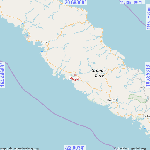
Poya GPS coordinates[2]
21° 21' 0" South, 165° 9' 0" East
| Map corner | latitude | longitude |
|---|---|---|
| Upper-left | -20.69368°, | 164.44688° |
| Center: | -21.35°, | 165.15° |
| Lower-right: | -22.0034°, | 165.85313° |
| Map W x H: | 145.6×145.6 km | = 90.5×90.5mi |
| max Lat: | -19.71161° ⇑53.3% North |
| Poya: | -21.35° |
| min Lat: | ⇓46.7% South -22.66645° |
| min Long | Poya | max Long |
| 163.64702° | 165.15° | 167.88019° |
| W 33.3%⇐ | ⇒66.7% E |
Elevation
Elevation of Poya is 11 m = 36 ft, and this is 32.3 m = 106 ft below average elevation for this country.
| Max E: |
275 m = 902 ft | 70% |
| Avg. | 43.3 m = 142 ft | |
| Poya | 11 m = 36 ft | |
Min E: |
1 m = 3 ft | 30% |
See also: New Caledonia elevation on elevation.city.
Geographical zone
Poya is located in South Torrid zone (between Equator and Tropic of Capricorn). Distance of this Southern Tropic circle is 232 km =144.2 mi to South.| Distance of | km | miles | from Poya |
|---|---|---|---|
| Equator | 2373.9 | 1475.1 | to North |
| Tropic Capricorn | 232 | 144.2 | to South |
| Antarctic Circle | 5027.3 | 3123.8 | to South |
| South Pole | 7633.2 | 4743 | to South |


Nearby cities:
15 places around Poya: (largest is in red/bold)
• Bouloupari
109.2 km =67.9 mi,  121°
121°
• Bourail
43.3 km =26.9 mi, 123°
• Canala
85.3 km =53 mi,  103°
103°
• Hienghène
77.5 km =48.2 mi,  343°
343°
• Houaïlou
48.9 km =30.4 mi,  81°
81°
• Kaala-Gomén
108.8 km =67.6 mi,  314°
314°
• Koné
43.7 km =27.2 mi,  317°
317°
• La Foa
80.8 km =50.2 mi, 119°
• Moindou
67.5 km =41.9 mi,  125°
125°
• Poindimié
50.1 km =31.1 mi,  22°
22°
• Ponérihouen
39.4 km =24.5 mi,  41°
41°
• Pouembout
35.4 km =22 mi, 312°
• Sarraméa
79.7 km =49.5 mi,  114°
114°
• Touho
63 km =39.1 mi,  9°
9°
• Voh
63.2 km =39.3 mi, 312°
Sources, notices
• [Note1] Compared only with cities in New Caledonia existing in our database
• [Src1] Map data: © OpenStreetMap contributors (CC-BY-SA)
• [Src2] Other city data from geonames.org with taken over terms of usage.
• [Src3] Geographical zone / Annual Mean Temperature by Robert A. Rohde @ Wikipedia
