Uromi geodata
Uromi (Edo) is a populated place; located in Nigeria in Africa/Lagos (GMT+1) time zone. With population of 108,608 people, there are 80 cities with bigger population in this country. Compared to other cities in Nigeria, 72.7% of cities are located further ↑North; 66.1% of cities are located further →East and 67.3% of cities have lower elevation than Uromi. Note1


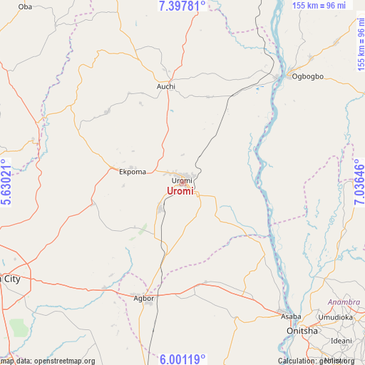
Uromi GPS coordinates[2]
6° 42' 0" North, 6° 19' 59.988" East
| Map corner | latitude | longitude |
|---|---|---|
| Upper-left | 7.39781°, | 5.63021° |
| Center: | 6.7°, | 6.33333° |
| Lower-right: | 6.00119°, | 7.03646° |
| Map W x H: | 155.3×155.3 km | = 96.5×96.5mi |
| max Lat: | 13.7543° ⇑72.7% North |
| Uromi: | 6.7° |
| min Lat: | ⇓27.3% South 4.31231° |
| min Long | Uromi | max Long |
| 2.73333° | 6.33333° | 14.46552° |
| W 33.9%⇐ | ⇒66.1% E |
Elevation
Elevation of Uromi is 381 m = 1250 ft, and this is 84.5 m = 277 ft above average elevation for this country.
| Max E: |
1599 m = 5246 ft | 32.7% |
| Uromi | 381 m 1250 ft | |
| Avg. | 296.5 m = 973 ft | |
Min E: |
2 m = 7 ft | 67.3% |
See also: Uromi elevation on elevation.city.
Geographical zone
Uromi is located in North Torrid zone (between Equator and Tropic of Cancer). Distance of Equator is 745 km =462.9 mi to South.| Distance of | km | miles | from Uromi |
|---|---|---|---|
| North Pole | 9262.1 | 5755.2 | to North |
| Arctic Circle | 6656.2 | 4136 | to North |
| Tropic Cancer | 1860.9 | 1156.3 | to North |
| Equator | 745 | 462.9 | to South |


Nearby cities:
15 places around Uromi: (largest is in red/bold)
• Afuze
43.9 km =27.3 mi,  313°
313°
• Akwukwu-Igbo
47.5 km =29.5 mi,  143°
143°
• Auchi
41.6 km =25.8 mi,  349°
349°
• Ehor
39.9 km =24.8 mi,  256°
256°
• Ekpoma
21.8 km =13.5 mi,  282°
282°
• Fugar
47.1 km =29.3 mi,  22°
22°
• Igueben
14.8 km =9.2 mi,  222°
222°
• Illushi
32.8 km =20.4 mi,  95°
95°
• Irrua
13.2 km =8.2 mi,  287°
287°
• Issele-Uku
45.5 km =28.3 mi,  159°
159°
• Nzam
51.6 km =32.1 mi,  122°
122°
• Onyedega
42.9 km =26.7 mi,  61°
61°
• Sabongida-Ora
49.8 km =30.9 mi,  296°
296°
• Ubiaja
7.5 km =4.7 mi,  130°
130°
• Umunede
48.4 km =30.1 mi,  183°
183°
Sources, notices
• [Note1] Compared only with cities in Nigeria existing in our database
• [Src1] Map data: © OpenStreetMap contributors (CC-BY-SA)
• [Src2] Other city data from geonames.org with taken over terms of usage.
• [Src3] Geographical zone / Annual Mean Temperature by Robert A. Rohde @ Wikipedia
