Ekpoma geodata
Ekpoma (Edo) is a seat of a second-order administrative division; located in Nigeria in Africa/Lagos (GMT+1) time zone. With population of 59,618 people, there are 145 cities with bigger population in this country. Compared to other cities in Nigeria, 71.9% of cities are located further ↑North; 69.2% of cities are located further →East and 64.1% of cities have lower elevation than Ekpoma. Note1


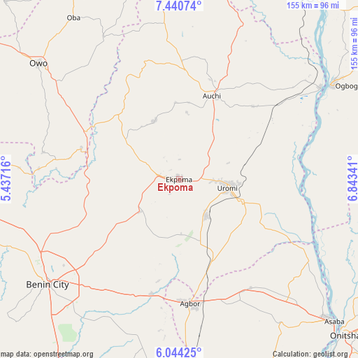
Ekpoma GPS coordinates[2]
6° 44' 34.8" North, 6° 8' 25.044" East
| Map corner | latitude | longitude |
|---|---|---|
| Upper-left | 7.44074°, | 5.43716° |
| Center: | 6.743°, | 6.14029° |
| Lower-right: | 6.04425°, | 6.84341° |
| Map W x H: | 155.3×155.3 km | = 96.5×96.5mi |
| max Lat: | 13.7543° ⇑71.9% North |
| Ekpoma: | 6.743° |
| min Lat: | ⇓28.1% South 4.31231° |
| min Long | Ekpoma | max Long |
| 2.73333° | 6.14029° | 14.46552° |
| W 30.8%⇐ | ⇒69.2% E |
Elevation
Elevation of Ekpoma is 364 m = 1194 ft, and this is 67.5 m = 221 ft above average elevation for this country.
| Max E: |
1599 m = 5246 ft | 35.9% |
| Ekpoma | 364 m 1194 ft | |
| Avg. | 296.5 m = 973 ft | |
Min E: |
2 m = 7 ft | 64.1% |
See also: Ekpoma elevation on elevation.city.
Geographical zone
Ekpoma is located in North Torrid zone (between Equator and Tropic of Cancer). Distance of Equator is 749.8 km =465.9 mi to South.| Distance of | km | miles | from Ekpoma |
|---|---|---|---|
| North Pole | 9257.3 | 5752.2 | to North |
| Arctic Circle | 6651.4 | 4133 | to North |
| Tropic Cancer | 1856.2 | 1153.4 | to North |
| Equator | 749.8 | 465.9 | to South |


Nearby cities:
15 places around Ekpoma: (largest is in red/bold)
• Abudu
51.3 km =31.9 mi,  193°
193°
• Afuze
27.4 km =17 mi,  336°
336°
• Agbor
54.7 km =34 mi,  173°
173°
• Auchi
38.6 km =24 mi,  20°
20°
• Ehor
22.5 km =14 mi,  230°
230°
• Fugar
55.3 km =34.4 mi,  45°
45°
• Ifon
45.5 km =28.3 mi,  297°
297°
• Igueben
19.4 km =12.1 mi,  144°
144°
• Illushi
54.6 km =33.9 mi,  98°
98°
• Irrua
8.8 km =5.5 mi,  94°
94°
• Issele-Uku
60.3 km =37.5 mi, 142°
• Sabongida-Ora
29.1 km =18.1 mi,  307°
307°
• Ubiaja
28.7 km =17.8 mi,  109°
109°
• Umunede
56.3 km =35 mi,  160°
160°
• Uromi
21.8 km =13.5 mi, 102°
Sources, notices
• [Note1] Compared only with cities in Nigeria existing in our database
• [Src1] Map data: © OpenStreetMap contributors (CC-BY-SA)
• [Src2] Other city data from geonames.org with taken over terms of usage.
• [Src3] Geographical zone / Annual Mean Temperature by Robert A. Rohde @ Wikipedia
