Kwale geodata
Kwale (Delta) is a seat of a second-order administrative division; located in Nigeria in Africa/Lagos (GMT+1) time zone. With population of 20,226 people, there are 200 cities with bigger population in this country. Compared to other cities in Nigeria, 87.6% of cities are located further ↑North; 65.4% of cities are located further →East and 91.9% of cities have higher elevation than Kwale. Note1


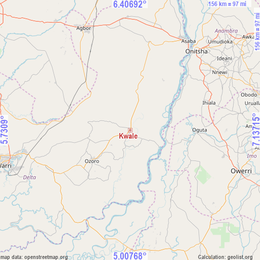
Kwale GPS coordinates[2]
5° 42' 27.828" North, 6° 26' 2.472" East
| Map corner | latitude | longitude |
|---|---|---|
| Upper-left | 6.40692°, | 5.7309° |
| Center: | 5.70773°, | 6.43402° |
| Lower-right: | 5.00768°, | 7.13715° |
| Map W x H: | 155.6×155.6 km | = 96.7×96.7mi |
| max Lat: | 13.7543° ⇑87.6% North |
| Kwale: | 5.70773° |
| min Lat: | ⇓12.4% South 4.31231° |
| min Long | Kwale | max Long |
| 2.73333° | 6.43402° | 14.46552° |
| W 34.6%⇐ | ⇒65.4% E |
Elevation
Elevation of Kwale is 22 m = 72 ft, and this is 274.5 m = 901 ft below average elevation for this country.
| Max E: |
1599 m = 5246 ft | 91.9% |
| Avg. | 296.5 m = 973 ft | |
| Kwale | 22 m = 72 ft | |
Min E: |
2 m = 7 ft | 8.1% |
See also: Nigeria elevation on elevation.city.
Geographical zone
Kwale is located in North Torrid zone (between Equator and Tropic of Cancer). Distance of Equator is 634.6 km =394.3 mi to South.| Distance of | km | miles | from Kwale |
|---|---|---|---|
| North Pole | 9372.4 | 5823.7 | to North |
| Arctic Circle | 6766.5 | 4204.5 | to North |
| Tropic Cancer | 1971.3 | 1224.9 | to North |
| Equator | 634.6 | 394.3 | to South |


Nearby cities:
15 places around Kwale: (largest is in red/bold)
• Aboh
20.5 km =12.7 mi,  150°
150°
• Abraka
37.6 km =23.4 mi,  284°
284°
• Atani
48.5 km =30.1 mi,  45°
45°
• Egbema
40.5 km =25.2 mi,  116°
116°
• Ihiala
49.8 km =30.9 mi,  70°
70°
• Isiokolo
49.6 km =30.8 mi,  255°
255°
• Mgbidi
50.4 km =31.3 mi,  86°
86°
• Obiaruku
34.7 km =21.6 mi,  296°
296°
• Oguta
41.5 km =25.8 mi, 89°
• Ogwashi-Uku
53.3 km =33.1 mi,  10°
10°
• Oleh
37.2 km =23.1 mi,  222°
222°
• Omoku
47.4 km =29.5 mi, 148°
• Ozoro
29.1 km =18.1 mi,  232°
232°
• Ughelli
53.4 km =33.2 mi,  242°
242°
• Uruobo-Okija
50.1 km =31.1 mi,  64°
64°
Sources, notices
• [Note1] Compared only with cities in Nigeria existing in our database
• [Src1] Map data: © OpenStreetMap contributors (CC-BY-SA)
• [Src2] Other city data from geonames.org with taken over terms of usage.
• [Src3] Geographical zone / Annual Mean Temperature by Robert A. Rohde @ Wikipedia
