Samamiya geodata
Samamiya (Jigawa) is a populated place; located in Nigeria in Africa/Lagos (GMT+1) time zone. With population of 8,087 people, there are 383 cities with bigger population in this country. Compared to other cities in Nigeria, 75.6% of cities are located further ↓South; 81.8% of cities are located further ←West and 75.8% of cities have lower elevation than Samamiya. Note1


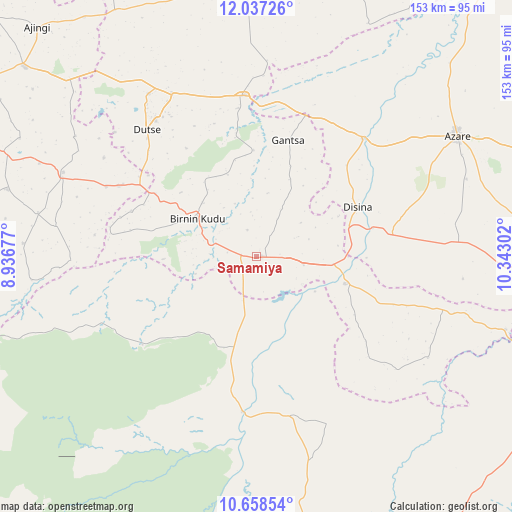
Samamiya GPS coordinates[2]
11° 20' 55.428" North, 9° 38' 23.604" East
| Map corner | latitude | longitude |
|---|---|---|
| Upper-left | 12.03726°, | 8.93677° |
| Center: | 11.34873°, | 9.63989° |
| Lower-right: | 10.65854°, | 10.34302° |
| Map W x H: | 153.3×153.3 km | = 95.3×95.3mi |
| max Lat: | 13.7543° ⇑24.4% North |
| Samamiya: | 11.34873° |
| min Lat: | ⇓75.6% South 4.31231° |
| min Long | Samamiya | max Long |
| 2.73333° | 9.63989° | 14.46552° |
| W 81.8%⇐ | ⇒18.2% E |
Elevation
Elevation of Samamiya is 437 m = 1434 ft, and this is 140.5 m = 461 ft above average elevation for this country.
| Max E: |
1599 m = 5246 ft | 24.2% |
| Samamiya | 437 m 1434 ft | |
| Avg. | 296.5 m = 973 ft | |
Min E: |
2 m = 7 ft | 75.8% |
See also: Nigeria elevation on elevation.city.
Geographical zone
Samamiya is located in North Torrid zone (between Equator and Tropic of Cancer). Distance of Equator is 1261.9 km =784.1 mi to South.| Distance of | km | miles | from Samamiya |
|---|---|---|---|
| North Pole | 8745.2 | 5434 | to North |
| Arctic Circle | 6139.3 | 3814.8 | to North |
| Tropic Cancer | 1344.1 | 835.2 | to North |
| Equator | 1261.9 | 784.1 | to South |


Nearby cities:
15 places around Samamiya: (largest is in red/bold)
• Albasu
65.3 km =40.6 mi,  303°
303°
• Azare
70.1 km =43.6 mi,  58°
58°
• Birnin Kudu
21 km =13 mi, 303°
• Disina
33.8 km =21 mi, 64°
• Dutse
55.9 km =34.7 mi,  324°
324°
• Gantsa
36.2 km =22.5 mi,  15°
15°
• Giade
61.2 km =38 mi,  85°
85°
• Gwaram
27.8 km =17.3 mi,  106°
106°
• Itas
66.7 km =41.4 mi,  31°
31°
• Jama’are
47.5 km =29.5 mi,  41°
41°
• Kiyawa
48.6 km =30.2 mi,  355°
355°
• Ningi
31 km =19.3 mi,  194°
194°
• Takai
63.1 km =39.2 mi,  293°
293°
• Warji
22.6 km =14 mi,  147°
147°
• Yana
41.2 km =25.6 mi,  80°
80°
Sources, notices
• [Note1] Compared only with cities in Nigeria existing in our database
• [Src1] Map data: © OpenStreetMap contributors (CC-BY-SA)
• [Src2] Other city data from geonames.org with taken over terms of usage.
• [Src3] Geographical zone / Annual Mean Temperature by Robert A. Rohde @ Wikipedia
