Kiyawa geodata
Kiyawa (Jigawa) is a seat of a second-order administrative division; located in Nigeria in Africa/Lagos (GMT+1) time zone. With population of 17,704 people, there are 210 cities with bigger population in this country. Compared to other cities in Nigeria, 81.8% of cities are located further ↓South; 81% of cities are located further ←West and 69.4% of cities have lower elevation than Kiyawa. Note1


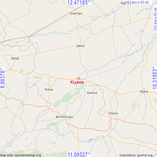
Kiyawa GPS coordinates[2]
11° 47' 3.912" North, 9° 36' 24.84" East
| Map corner | latitude | longitude |
|---|---|---|
| Upper-left | 12.47185°, | 8.90378° |
| Center: | 11.78442°, | 9.6069° |
| Lower-right: | 11.09527°, | 10.31003° |
| Map W x H: | 153.1×153.1 km | = 95.1×95.1mi |
| max Lat: | 13.7543° ⇑18.2% North |
| Kiyawa: | 11.78442° |
| min Lat: | ⇓81.8% South 4.31231° |
| min Long | Kiyawa | max Long |
| 2.73333° | 9.6069° | 14.46552° |
| W 81%⇐ | ⇒19% E |
Elevation
Elevation of Kiyawa is 395 m = 1296 ft, and this is 98.5 m = 323 ft above average elevation for this country.
| Max E: |
1599 m = 5246 ft | 30.6% |
| Kiyawa | 395 m 1296 ft | |
| Avg. | 296.5 m = 973 ft | |
Min E: |
2 m = 7 ft | 69.4% |
See also: Nigeria elevation on elevation.city.
Geographical zone
Kiyawa is located in North Torrid zone (between Equator and Tropic of Cancer). Distance of this Northern Tropic circle is 1295.6 km =805 mi to North.| Distance of | km | miles | from Kiyawa |
|---|---|---|---|
| North Pole | 8696.8 | 5403.9 | to North |
| Arctic Circle | 6090.9 | 3784.7 | to North |
| Tropic Cancer | 1295.6 | 805 | to North |
| Equator | 1310.3 | 814.2 | to South |


Nearby cities:
15 places around Kiyawa: (largest is in red/bold)
• Albasu
52.2 km =32.4 mi,  256°
256°
• Birnin Kudu
39.5 km =24.5 mi,  200°
200°
• Disina
47.9 km =29.8 mi,  134°
134°
• Dutse
29.3 km =18.2 mi, 263°
• Gantsa
18.7 km =11.6 mi,  136°
136°
• Itas
39.7 km =24.7 mi,  78°
78°
• Jahun
32.5 km =20.2 mi,  3°
3°
• Jama’are
37.2 km =23.1 mi,  110°
110°
• Kafin Hausa
60.4 km =37.5 mi,  33°
33°
• Miga
51.8 km =32.2 mi,  12°
12°
• Ringim
63.3 km =39.3 mi,  310°
310°
• Samamiya
48.6 km =30.2 mi,  175°
175°
• Takai
59 km =36.7 mi,  246°
246°
• Taura
60.5 km =37.6 mi,  324°
324°
• Yana
61 km =37.9 mi, 133°
Sources, notices
• [Note1] Compared only with cities in Nigeria existing in our database
• [Src1] Map data: © OpenStreetMap contributors (CC-BY-SA)
• [Src2] Other city data from geonames.org with taken over terms of usage.
• [Src3] Geographical zone / Annual Mean Temperature by Robert A. Rohde @ Wikipedia
