Share geodata
Share (Kwara) is a seat of a second-order administrative division; located in Nigeria in Africa/Lagos (GMT+1) time zone. In our database, there are 451 cities with bigger population. Compared to other cities in Nigeria, 52.9% of cities are located further ↓South; 81.9% of cities are located further →East and 52.2% of cities have lower elevation than Share. Note1


Share GPS coordinates[2]
8° 49' 15.096" North, 4° 58' 24.312" East
| Map corner | latitude | longitude |
|---|---|---|
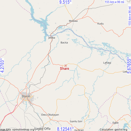
| Upper-left | 9.515°, | 4.2703° |
| Center: | 8.82086°, | 4.97342° |
| Lower-right: | 8.12541°, | 5.67655° |
| Map W x H: | 154.5×154.5 km | = 96×96mi |
| max Lat: | 13.7543° ⇑47.1% North |
| Share: | 8.82086° |
| min Lat: | ⇓52.9% South 4.31231° |
| min Long | Share | max Long |
| 2.73333° | 4.97342° | 14.46552° |
| W 18.1%⇐ | ⇒81.9% E |
Elevation
Elevation of Share is 295 m = 968 ft, and this is 1.5 m = 5 ft below average elevation for this country.
| Max E: |
1599 m = 5246 ft | 47.8% |
| Avg. | 296.5 m = 973 ft | |
| Share | 295 m = 968 ft | |
Min E: |
2 m = 7 ft | 52.2% |
See also: Nigeria elevation on elevation.city.
Geographical zone
Share is located in North Torrid zone (between Equator and Tropic of Cancer). Distance of Equator is 980.8 km =609.4 mi to South.| Distance of | km | miles | from Share |
|---|---|---|---|
| North Pole | 9026.3 | 5608.7 | to North |
| Arctic Circle | 6420.4 | 3989.5 | to North |
| Tropic Cancer | 1625.1 | 1009.8 | to North |
| Equator | 980.8 | 609.4 | to South |


Nearby cities:
15 places around Share: (largest is in red/bold)
• Afon
74.8 km =46.5 mi,  220°
220°
• Ajasse Ipo
67.6 km =42 mi,  194°
194°
• Alapa
68.7 km =42.7 mi,  250°
250°
• Bode Saadu
24.8 km =15.4 mi,  302°
302°
• Bokani
72.5 km =45 mi,  20°
20°
• Enagi
71.3 km =44.3 mi,  61°
61°
• Fufu
49.9 km =31 mi,  213°
213°
• Ilorin
59.6 km =37 mi,  232°
232°
• Jebba
37.1 km =23.1 mi,  333°
333°
• Lafiagi
48.8 km =30.3 mi,  85°
85°
• Mokwa
53.4 km =33.2 mi,  9°
9°
• Offa
79.7 km =49.5 mi,  200°
200°
• Oke-Oyi
38.7 km =24 mi, 226°
• Omu-Aran
77.2 km =48 mi,  169°
169°
• Owu-Isin
60.3 km =37.5 mi,  175°
175°
Sources, notices
• [Note1] Compared only with cities in Nigeria existing in our database
• [Src1] Map data: © OpenStreetMap contributors (CC-BY-SA)
• [Src2] Other city data from geonames.org with taken over terms of usage.
• [Src3] Geographical zone / Annual Mean Temperature by Robert A. Rohde @ Wikipedia
