Lafiagi geodata
Lafiagi (Kwara) is a seat of a second-order administrative division; located in Nigeria in Africa/Lagos (GMT+1) time zone. With population of 102,779 people, there are 86 cities with bigger population in this country. Compared to other cities in Nigeria, 53.5% of cities are located further ↓South; 76.7% of cities are located further →East and 75.5% of cities have higher elevation than Lafiagi. Note1


Lafiagi GPS coordinates[2]
8° 51' 10.764" North, 5° 24' 59.076" East
| Map corner | latitude | longitude |
|---|---|---|
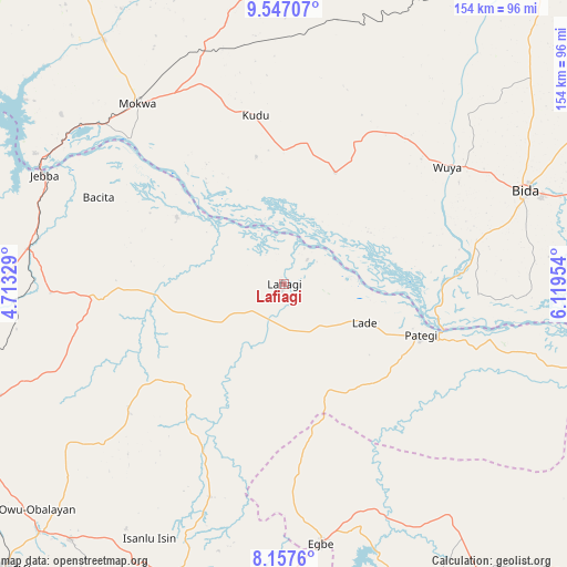
| Upper-left | 9.54707°, | 4.71329° |
| Center: | 8.85299°, | 5.41641° |
| Lower-right: | 8.1576°, | 6.11954° |
| Map W x H: | 154.5×154.5 km | = 96×96mi |
| max Lat: | 13.7543° ⇑46.5% North |
| Lafiagi: | 8.85299° |
| min Lat: | ⇓53.5% South 4.31231° |
| min Long | Lafiagi | max Long |
| 2.73333° | 5.41641° | 14.46552° |
| W 23.3%⇐ | ⇒76.7% E |
Elevation
Elevation of Lafiagi is 116 m = 381 ft, and this is 180.5 m = 592 ft below average elevation for this country.
| Max E: |
1599 m = 5246 ft | 75.5% |
| Avg. | 296.5 m = 973 ft | |
| Lafiagi | 116 m = 381 ft | |
Min E: |
2 m = 7 ft | 24.5% |
See also: Lafiagi elevation on elevation.city.
Geographical zone
Lafiagi is located in North Torrid zone (between Equator and Tropic of Cancer). Distance of Equator is 984.4 km =611.7 mi to South.| Distance of | km | miles | from Lafiagi |
|---|---|---|---|
| North Pole | 9022.7 | 5606.4 | to North |
| Arctic Circle | 6416.8 | 3987.2 | to North |
| Tropic Cancer | 1621.6 | 1007.6 | to North |
| Equator | 984.4 | 611.7 | to South |


Nearby cities:
15 places around Lafiagi: (largest is in red/bold)
• Bida
69.9 km =43.4 mi,  68°
68°
• Bode Saadu
70.3 km =43.7 mi,  277°
277°
• Bokani
68.8 km =42.8 mi,  339°
339°
• Egbe
71.6 km =44.5 mi,  171°
171°
• Enagi
33.6 km =20.9 mi,  24°
24°
• Isanlu
76.8 km =47.7 mi,  144°
144°
• Isanlu-Itedoijowa
79.1 km =49.2 mi, 144°
• Jebba
71.5 km =44.4 mi,  294°
294°
• Kutigi
43.4 km =27 mi,  26°
26°
• Mokwa
63.2 km =39.3 mi,  321°
321°
• Odo-Ere
68.6 km =42.6 mi, 167°
• Oke-Oyi
82.6 km =51.3 mi,  248°
248°
• Owu-Isin
77.1 km =47.9 mi,  214°
214°
• Patigi
39.8 km =24.7 mi,  110°
110°
• Share
48.8 km =30.3 mi,  265°
265°
Sources, notices
• [Note1] Compared only with cities in Nigeria existing in our database
• [Src1] Map data: © OpenStreetMap contributors (CC-BY-SA)
• [Src2] Other city data from geonames.org with taken over terms of usage.
• [Src3] Geographical zone / Annual Mean Temperature by Robert A. Rohde @ Wikipedia
