Enagi geodata
Enagi (Niger) is a seat of a second-order administrative division; located in Nigeria in Africa/Lagos (GMT+1) time zone. In our database, there are 451 cities with bigger population. Compared to other cities in Nigeria, 56.2% of cities are located further ↓South; 75.4% of cities are located further →East and 65.4% of cities have higher elevation than Enagi. Note1


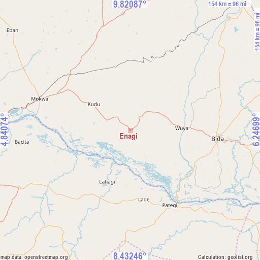
Enagi GPS coordinates[2]
9° 7' 38.424" North, 5° 32' 37.932" East
| Map corner | latitude | longitude |
|---|---|---|
| Upper-left | 9.82087°, | 4.84074° |
| Center: | 9.12734°, | 5.54387° |
| Lower-right: | 8.43246°, | 6.24699° |
| Map W x H: | 154.4×154.4 km | = 95.9×95.9mi |
| max Lat: | 13.7543° ⇑43.8% North |
| Enagi: | 9.12734° |
| min Lat: | ⇓56.2% South 4.31231° |
| min Long | Enagi | max Long |
| 2.73333° | 5.54387° | 14.46552° |
| W 24.6%⇐ | ⇒75.4% E |
Elevation
Elevation of Enagi is 174 m = 571 ft, and this is 122.5 m = 402 ft below average elevation for this country.
| Max E: |
1599 m = 5246 ft | 65.4% |
| Avg. | 296.5 m = 973 ft | |
| Enagi | 174 m = 571 ft | |
Min E: |
2 m = 7 ft | 34.6% |
See also: Nigeria elevation on elevation.city.
Geographical zone
Enagi is located in North Torrid zone (between Equator and Tropic of Cancer). Distance of Equator is 1014.9 km =630.6 mi to South.| Distance of | km | miles | from Enagi |
|---|---|---|---|
| North Pole | 8992.2 | 5587.5 | to North |
| Arctic Circle | 6386.3 | 3968.3 | to North |
| Tropic Cancer | 1591.1 | 988.7 | to North |
| Equator | 1014.9 | 630.6 | to South |


Nearby cities:
15 places around Enagi: (largest is in red/bold)
• Agaie
86 km =53.4 mi,  98°
98°
• Badeggi
66.3 km =41.2 mi, 96°
• Bida
51.4 km =31.9 mi, 95°
• Bode Saadu
86.2 km =53.6 mi,  255°
255°
• Bokani
50.8 km =31.6 mi,  312°
312°
• Jebba
79.1 km =49.2 mi,  269°
269°
• Katcha
93.7 km =58.2 mi,  115°
115°
• Kutigi
9.9 km =6.2 mi,  34°
34°
• Lafiagi
33.6 km =20.9 mi,  204°
204°
• Lemu
61 km =37.9 mi,  60°
60°
• Mashegu
97.4 km =60.5 mi,  15°
15°
• Mokwa
56.9 km =35.4 mi,  289°
289°
• Patigi
50.1 km =31.1 mi,  152°
152°
• Share
71.3 km =44.3 mi,  241°
241°
• Wushishi
88.7 km =55.1 mi,  40°
40°
Sources, notices
• [Note1] Compared only with cities in Nigeria existing in our database
• [Src1] Map data: © OpenStreetMap contributors (CC-BY-SA)
• [Src2] Other city data from geonames.org with taken over terms of usage.
• [Src3] Geographical zone / Annual Mean Temperature by Robert A. Rohde @ Wikipedia
