Mokwa geodata
Mokwa (Niger) is a seat of a second-order administrative division; located in Nigeria in Africa/Lagos (GMT+1) time zone. With population of 21,128 people, there are 195 cities with bigger population in this country. Compared to other cities in Nigeria, 57.7% of cities are located further ↓South; 80.9% of cities are located further →East and 68.7% of cities have higher elevation than Mokwa. Note1


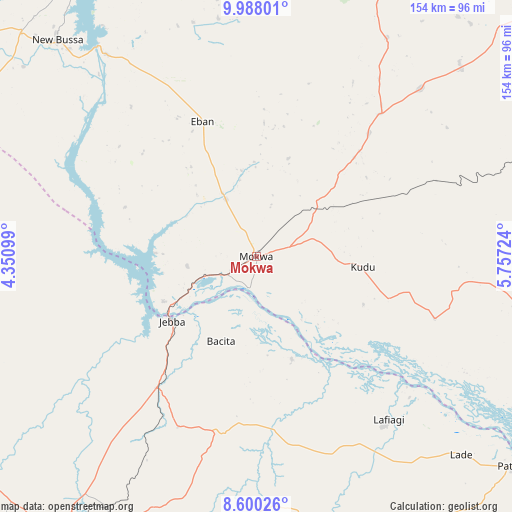
Mokwa GPS coordinates[2]
9° 17' 41.352" North, 5° 3' 14.832" East
| Map corner | latitude | longitude |
|---|---|---|
| Upper-left | 9.98801°, | 4.35099° |
| Center: | 9.29482°, | 5.05412° |
| Lower-right: | 8.60026°, | 5.75724° |
| Map W x H: | 154.3×154.3 km | = 95.9×95.9mi |
| max Lat: | 13.7543° ⇑42.3% North |
| Mokwa: | 9.29482° |
| min Lat: | ⇓57.7% South 4.31231° |
| min Long | Mokwa | max Long |
| 2.73333° | 5.05412° | 14.46552° |
| W 19.1%⇐ | ⇒80.9% E |
Elevation
Elevation of Mokwa is 153 m = 502 ft, and this is 143.5 m = 471 ft below average elevation for this country.
| Max E: |
1599 m = 5246 ft | 68.7% |
| Avg. | 296.5 m = 973 ft | |
| Mokwa | 153 m = 502 ft | |
Min E: |
2 m = 7 ft | 31.3% |
See also: Nigeria elevation on elevation.city.
Geographical zone
Mokwa is located in North Torrid zone (between Equator and Tropic of Cancer). Distance of Equator is 1033.5 km =642.2 mi to South.| Distance of | km | miles | from Mokwa |
|---|---|---|---|
| North Pole | 8973.6 | 5575.9 | to North |
| Arctic Circle | 6367.7 | 3956.7 | to North |
| Tropic Cancer | 1572.4 | 977 | to North |
| Equator | 1033.5 | 642.2 | to South |


Nearby cities:
15 places around Mokwa: (largest is in red/bold)
• Alapa
105.4 km =65.5 mi,  224°
224°
• Auna
105.7 km =65.7 mi,  339°
339°
• Bode Saadu
49.6 km =30.8 mi, 217°
• Bokani
22.2 km =13.8 mi,  46°
46°
• Enagi
56.9 km =35.4 mi,  109°
109°
• Fufu
101 km =62.8 mi,  201°
201°
• Ilorin
105.1 km =65.3 mi,  212°
212°
• Jebba
31.9 km =19.8 mi,  232°
232°
• Kutigi
60.3 km =37.5 mi,  99°
99°
• Lafiagi
63.2 km =39.3 mi,  141°
141°
• New Bussa
88.9 km =55.2 mi,  317°
317°
• Oke-Oyi
87.5 km =54.4 mi, 205°
• Patigi
99.5 km =61.8 mi,  129°
129°
• Share
53.4 km =33.2 mi,  189°
189°
• Wawa
97 km =60.3 mi,  314°
314°
Sources, notices
• [Note1] Compared only with cities in Nigeria existing in our database
• [Src1] Map data: © OpenStreetMap contributors (CC-BY-SA)
• [Src2] Other city data from geonames.org with taken over terms of usage.
• [Src3] Geographical zone / Annual Mean Temperature by Robert A. Rohde @ Wikipedia
