Gantsa geodata
Gantsa (Jigawa) is a seat of a second-order administrative division; located in Nigeria in Africa/Lagos (GMT+1) time zone. In our database, there are 451 cities with bigger population. Compared to other cities in Nigeria, 79.6% of cities are located further ↓South; 82.3% of cities are located further ←West and 70.8% of cities have lower elevation than Gantsa. Note1


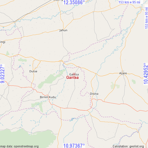
Gantsa GPS coordinates[2]
11° 39' 47.232" North, 9° 43' 35.004" East
| Map corner | latitude | longitude |
|---|---|---|
| Upper-left | 12.35086°, | 9.02327° |
| Center: | 11.66312°, | 9.72639° |
| Lower-right: | 10.97367°, | 10.42952° |
| Map W x H: | 153.1×153.1 km | = 95.1×95.1mi |
| max Lat: | 13.7543° ⇑20.4% North |
| Gantsa: | 11.66312° |
| min Lat: | ⇓79.6% South 4.31231° |
| min Long | Gantsa | max Long |
| 2.73333° | 9.72639° | 14.46552° |
| W 82.3%⇐ | ⇒17.7% E |
Elevation
Elevation of Gantsa is 404 m = 1325 ft, and this is 107.5 m = 353 ft above average elevation for this country.
| Max E: |
1599 m = 5246 ft | 29.2% |
| Gantsa | 404 m 1325 ft | |
| Avg. | 296.5 m = 973 ft | |
Min E: |
2 m = 7 ft | 70.8% |
See also: Nigeria elevation on elevation.city.
Geographical zone
Gantsa is located in North Torrid zone (between Equator and Tropic of Cancer). Distance of Equator is 1296.8 km =805.8 mi to South.| Distance of | km | miles | from Gantsa |
|---|---|---|---|
| North Pole | 8710.2 | 5412.3 | to North |
| Arctic Circle | 6104.4 | 3793.1 | to North |
| Tropic Cancer | 1309.1 | 813.4 | to North |
| Equator | 1296.8 | 805.8 | to South |


Nearby cities:
15 places around Gantsa: (largest is in red/bold)
• Albasu
63.8 km =39.6 mi,  271°
271°
• Azare
50.6 km =31.4 mi,  88°
88°
• Birnin Kudu
35.8 km =22.2 mi,  229°
229°
• Disina
29.1 km =18.1 mi,  133°
133°
• Dutse
43.4 km =27 mi,  283°
283°
• Giade
59.8 km =37.2 mi,  120°
120°
• Gwaram
46.2 km =28.7 mi,  158°
158°
• Itas
33.7 km =20.9 mi,  50°
50°
• Jahun
47.2 km =29.3 mi,  346°
346°
• Jama’are
22 km =13.7 mi, 88°
• Kiyawa
18.7 km =11.6 mi,  316°
316°
• Miga
64 km =39.8 mi,  358°
358°
• Samamiya
36.2 km =22.5 mi,  195°
195°
• Warji
54.1 km =33.6 mi,  176°
176°
• Yana
42.3 km =26.3 mi, 132°
Sources, notices
• [Note1] Compared only with cities in Nigeria existing in our database
• [Src1] Map data: © OpenStreetMap contributors (CC-BY-SA)
• [Src2] Other city data from geonames.org with taken over terms of usage.
• [Src3] Geographical zone / Annual Mean Temperature by Robert A. Rohde @ Wikipedia
