Ruma geodata
Ruma (Katsina) is a populated place; located in Nigeria in Africa/Lagos (GMT+1) time zone. With population of 8,857 people, there are 361 cities with bigger population in this country. Compared to other cities in Nigeria, 95.6% of cities are located further ↓South; 51.8% of cities are located further →East and 84.8% of cities have lower elevation than Ruma. Note1


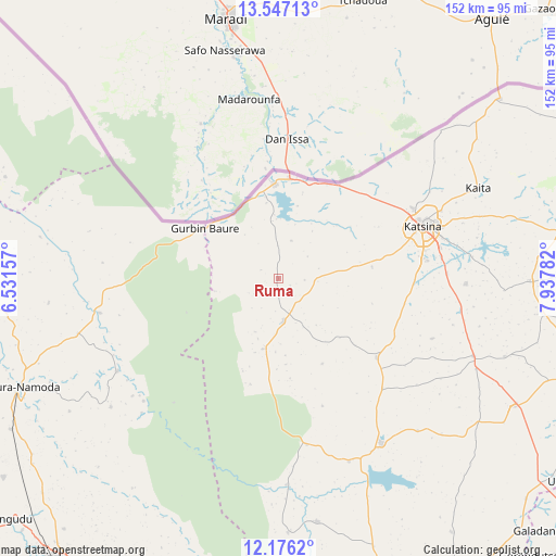
Ruma GPS coordinates[2]
12° 51' 45.36" North, 7° 14' 4.884" East
| Map corner | latitude | longitude |
|---|---|---|
| Upper-left | 13.54713°, | 6.53157° |
| Center: | 12.8626°, | 7.23469° |
| Lower-right: | 12.1762°, | 7.93782° |
| Map W x H: | 152.4×152.4 km | = 94.7×94.7mi |
| max Lat: | 13.7543° ⇑4.4% North |
| Ruma: | 12.8626° |
| min Lat: | ⇓95.6% South 4.31231° |
| min Long | Ruma | max Long |
| 2.73333° | 7.23469° | 14.46552° |
| W 48.2%⇐ | ⇒51.8% E |
Elevation
Elevation of Ruma is 502 m = 1647 ft, and this is 205.5 m = 674 ft above average elevation for this country.
| Max E: |
1599 m = 5246 ft | 15.2% |
| Ruma | 502 m 1647 ft | |
| Avg. | 296.5 m = 973 ft | |
Min E: |
2 m = 7 ft | 84.8% |
See also: Nigeria elevation on elevation.city.
Geographical zone
Ruma is located in North Torrid zone (between Equator and Tropic of Cancer). Distance of this Northern Tropic circle is 1175.7 km =730.5 mi to North.| Distance of | km | miles | from Ruma |
|---|---|---|---|
| North Pole | 8576.9 | 5329.4 | to North |
| Arctic Circle | 5971 | 3710.2 | to North |
| Tropic Cancer | 1175.7 | 730.5 | to North |
| Equator | 1430.2 | 888.7 | to South |


Nearby cities:
15 places around Ruma: (largest is in red/bold)
• Batagarawa
40.5 km =25.2 mi,  83°
83°
• Batsari
12 km =7.5 mi,  173°
173°
• Bindawa
65.8 km =40.9 mi,  108°
108°
• Birnin Magaji
50 km =31.1 mi,  227°
227°
• Charanchi
57.7 km =35.9 mi, 111°
• Dutsin-Ma
53.6 km =33.3 mi,  147°
147°
• Jibia
25.7 km =16 mi,  357°
357°
• Kaita
60.1 km =37.3 mi,  65°
65°
• Katsina
42.3 km =26.3 mi, 70°
• Kurfi
34.8 km =21.6 mi,  128°
128°
• Rimi
51.5 km =32 mi,  91°
91°
• Runka
46.8 km =29.1 mi, 170°
• Safana
53.9 km =33.5 mi,  158°
158°
• Wagini
19.9 km =12.4 mi,  192°
192°
• Zurmi
49.8 km =30.9 mi,  258°
258°
Sources, notices
• [Note1] Compared only with cities in Nigeria existing in our database
• [Src1] Map data: © OpenStreetMap contributors (CC-BY-SA)
• [Src2] Other city data from geonames.org with taken over terms of usage.
• [Src3] Geographical zone / Annual Mean Temperature by Robert A. Rohde @ Wikipedia
