Batsari geodata
Batsari (Katsina) is a seat of a second-order administrative division; located in Nigeria in Africa/Lagos (GMT+1) time zone. With population of 7,445 people, there are 401 cities with bigger population in this country. Compared to other cities in Nigeria, 94.1% of cities are located further ↓South; 51.5% of cities are located further →East and 80.1% of cities have lower elevation than Batsari. Note1


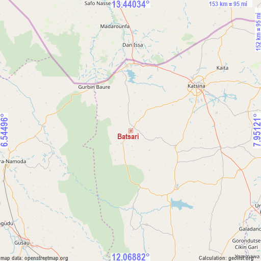
Batsari GPS coordinates[2]
12° 45' 19.836" North, 7° 14' 53.124" East
| Map corner | latitude | longitude |
|---|---|---|
| Upper-left | 13.44034°, | 6.54496° |
| Center: | 12.75551°, | 7.24809° |
| Lower-right: | 12.06882°, | 7.95121° |
| Map W x H: | 152.5×152.5 km | = 94.8×94.8mi |
| max Lat: | 13.7543° ⇑5.9% North |
| Batsari: | 12.75551° |
| min Lat: | ⇓94.1% South 4.31231° |
| min Long | Batsari | max Long |
| 2.73333° | 7.24809° | 14.46552° |
| W 48.5%⇐ | ⇒51.5% E |
Elevation
Elevation of Batsari is 471 m = 1545 ft, and this is 174.5 m = 573 ft above average elevation for this country.
| Max E: |
1599 m = 5246 ft | 19.9% |
| Batsari | 471 m 1545 ft | |
| Avg. | 296.5 m = 973 ft | |
Min E: |
2 m = 7 ft | 80.1% |
See also: Nigeria elevation on elevation.city.
Geographical zone
Batsari is located in North Torrid zone (between Equator and Tropic of Cancer). Distance of this Northern Tropic circle is 1187.6 km =737.9 mi to North.| Distance of | km | miles | from Batsari |
|---|---|---|---|
| North Pole | 8588.8 | 5336.8 | to North |
| Arctic Circle | 5982.9 | 3717.6 | to North |
| Tropic Cancer | 1187.6 | 737.9 | to North |
| Equator | 1418.3 | 881.3 | to South |


Nearby cities:
15 places around Batsari: (largest is in red/bold)
• Batagarawa
42.2 km =26.2 mi,  66°
66°
• Bindawa
61.5 km =38.2 mi,  98°
98°
• Birnin Magaji
44.1 km =27.4 mi,  240°
240°
• Charanchi
53 km =32.9 mi, 100°
• Dan Musa
55.7 km =34.6 mi,  170°
170°
• Dutsin-Ma
43.1 km =26.8 mi,  141°
141°
• Jibia
37.7 km =23.4 mi,  356°
356°
• Katsina
46.4 km =28.8 mi,  55°
55°
• Kurfi
27.5 km =17.1 mi,  111°
111°
• Rimi
51.2 km =31.8 mi,  78°
78°
• Ruma
12 km =7.5 mi,  353°
353°
• Runka
34.8 km =21.6 mi, 169°
• Safana
42.4 km =26.3 mi,  154°
154°
• Wagini
9.4 km =5.8 mi,  217°
217°
• Zurmi
50.4 km =31.3 mi,  272°
272°
Sources, notices
• [Note1] Compared only with cities in Nigeria existing in our database
• [Src1] Map data: © OpenStreetMap contributors (CC-BY-SA)
• [Src2] Other city data from geonames.org with taken over terms of usage.
• [Src3] Geographical zone / Annual Mean Temperature by Robert A. Rohde @ Wikipedia
