Wagini geodata
Wagini (Katsina) is a populated place; located in Nigeria in Africa/Lagos (GMT+1) time zone. With population of 9,986 people, there are 335 cities with bigger population in this country. Compared to other cities in Nigeria, 93.5% of cities are located further ↓South; 52.7% of cities are located further →East and 82.8% of cities have lower elevation than Wagini. Note1


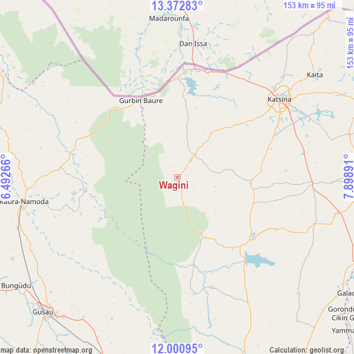
Wagini GPS coordinates[2]
12° 41' 16.116" North, 7° 11' 44.844" East
| Map corner | latitude | longitude |
|---|---|---|
| Upper-left | 13.37283°, | 6.49266° |
| Center: | 12.68781°, | 7.19579° |
| Lower-right: | 12.00095°, | 7.89891° |
| Map W x H: | 152.5×152.5 km | = 94.8×94.8mi |
| max Lat: | 13.7543° ⇑6.5% North |
| Wagini: | 12.68781° |
| min Lat: | ⇓93.5% South 4.31231° |
| min Long | Wagini | max Long |
| 2.73333° | 7.19579° | 14.46552° |
| W 47.3%⇐ | ⇒52.7% E |
Elevation
Elevation of Wagini is 488 m = 1601 ft, and this is 191.5 m = 628 ft above average elevation for this country.
| Max E: |
1599 m = 5246 ft | 17.2% |
| Wagini | 488 m 1601 ft | |
| Avg. | 296.5 m = 973 ft | |
Min E: |
2 m = 7 ft | 82.8% |
See also: Nigeria elevation on elevation.city.
Geographical zone
Wagini is located in North Torrid zone (between Equator and Tropic of Cancer). Distance of this Northern Tropic circle is 1195.2 km =742.7 mi to North.| Distance of | km | miles | from Wagini |
|---|---|---|---|
| North Pole | 8596.3 | 5341.5 | to North |
| Arctic Circle | 5990.4 | 3722.3 | to North |
| Tropic Cancer | 1195.2 | 742.7 | to North |
| Equator | 1410.8 | 876.6 | to South |


Nearby cities:
15 places around Wagini: (largest is in red/bold)
• Batagarawa
50.7 km =31.5 mi,  61°
61°
• Batsari
9.4 km =5.8 mi,  37°
37°
• Bindawa
66.5 km =41.3 mi,  91°
91°
• Birnin Magaji
35.7 km =22.2 mi,  246°
246°
• Charanchi
57.9 km =36 mi, 91°
• Dan Musa
49.7 km =30.9 mi,  162°
162°
• Dutsin-Ma
41.8 km =26 mi,  128°
128°
• Jibia
45.3 km =28.1 mi,  4°
4°
• Katsina
55.4 km =34.4 mi,  52°
52°
• Kurfi
31.4 km =19.5 mi, 94°
• Rimi
58.6 km =36.4 mi,  72°
72°
• Ruma
19.9 km =12.4 mi,  12°
12°
• Runka
29.4 km =18.3 mi, 155°
• Safana
38.9 km =24.2 mi,  142°
142°
• Zurmi
45.7 km =28.4 mi,  282°
282°
Sources, notices
• [Note1] Compared only with cities in Nigeria existing in our database
• [Src1] Map data: © OpenStreetMap contributors (CC-BY-SA)
• [Src2] Other city data from geonames.org with taken over terms of usage.
• [Src3] Geographical zone / Annual Mean Temperature by Robert A. Rohde @ Wikipedia
