Runka geodata
Runka (Katsina) is a populated place; located in Nigeria in Africa/Lagos (GMT+1) time zone. With population of 12,665 people, there are 281 cities with bigger population in this country. Compared to other cities in Nigeria, 89.8% of cities are located further ↓South; 50.6% of cities are located further →East and 83% of cities have lower elevation than Runka. Note1


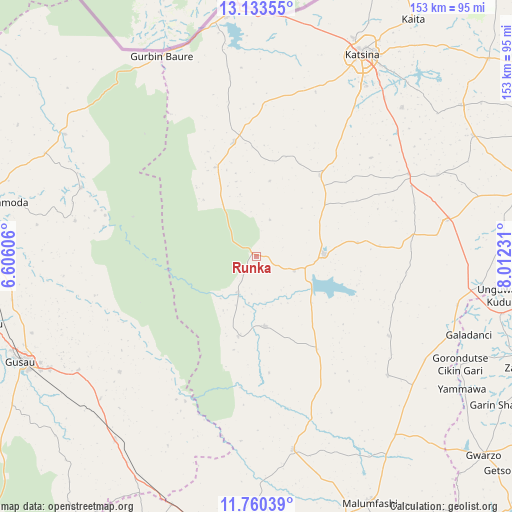
Runka GPS coordinates[2]
12° 26' 52.368" North, 7° 18' 33.048" East
| Map corner | latitude | longitude |
|---|---|---|
| Upper-left | 13.13355°, | 6.60606° |
| Center: | 12.44788°, | 7.30918° |
| Lower-right: | 11.76039°, | 8.01231° |
| Map W x H: | 152.7×152.7 km | = 94.9×94.9mi |
| max Lat: | 13.7543° ⇑10.2% North |
| Runka: | 12.44788° |
| min Lat: | ⇓89.8% South 4.31231° |
| min Long | Runka | max Long |
| 2.73333° | 7.30918° | 14.46552° |
| W 49.4%⇐ | ⇒50.6% E |
Elevation
Elevation of Runka is 489 m = 1604 ft, and this is 192.5 m = 632 ft above average elevation for this country.
| Max E: |
1599 m = 5246 ft | 17% |
| Runka | 489 m 1604 ft | |
| Avg. | 296.5 m = 973 ft | |
Min E: |
2 m = 7 ft | 83% |
See also: Nigeria elevation on elevation.city.
Geographical zone
Runka is located in North Torrid zone (between Equator and Tropic of Cancer). Distance of this Northern Tropic circle is 1221.8 km =759.2 mi to North.| Distance of | km | miles | from Runka |
|---|---|---|---|
| North Pole | 8623 | 5358.1 | to North |
| Arctic Circle | 6017.1 | 3738.9 | to North |
| Tropic Cancer | 1221.8 | 759.2 | to North |
| Equator | 1384.1 | 860 | to South |


Nearby cities:
15 places around Runka: (largest is in red/bold)
• Batsari
34.8 km =21.6 mi,  349°
349°
• Bindawa
59.6 km =37 mi,  65°
65°
• Birnin Magaji
46.7 km =29 mi,  285°
285°
• Charanchi
51.9 km =32.2 mi,  61°
61°
• Dan Musa
20.9 km =13 mi,  172°
172°
• Dutsin-Ma
20.4 km =12.7 mi,  88°
88°
• Jikamshi
59 km =36.7 mi,  121°
121°
• Kankara
58.5 km =36.4 mi, 169°
• Kankia
56.8 km =35.3 mi,  78°
78°
• Kurfi
30.9 km =19.2 mi,  38°
38°
• Matazu
46.2 km =28.7 mi, 120°
• Musawa
52.8 km =32.8 mi,  132°
132°
• Ruma
46.8 km =29.1 mi, 350°
• Safana
12.2 km =7.6 mi,  109°
109°
• Wagini
29.4 km =18.3 mi,  335°
335°
Sources, notices
• [Note1] Compared only with cities in Nigeria existing in our database
• [Src1] Map data: © OpenStreetMap contributors (CC-BY-SA)
• [Src2] Other city data from geonames.org with taken over terms of usage.
• [Src3] Geographical zone / Annual Mean Temperature by Robert A. Rohde @ Wikipedia
