Rijau geodata
Rijau (Niger) is a seat of a second-order administrative division; located in Nigeria in Africa/Lagos (GMT+1) time zone. With population of 16,613 people, there are 222 cities with bigger population in this country. Compared to other cities in Nigeria, 73.3% of cities are located further ↓South; 77.6% of cities are located further →East and 62.8% of cities have lower elevation than Rijau. Note1


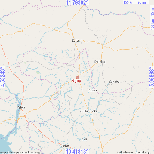
Rijau GPS coordinates[2]
11° 6' 14.004" North, 5° 15' 20.016" East
| Map corner | latitude | longitude |
|---|---|---|
| Upper-left | 11.79302°, | 4.55243° |
| Center: | 11.10389°, | 5.25556° |
| Lower-right: | 10.41313°, | 5.95868° |
| Map W x H: | 153.4×153.4 km | = 95.3×95.3mi |
| max Lat: | 13.7543° ⇑26.7% North |
| Rijau: | 11.10389° |
| min Lat: | ⇓73.3% South 4.31231° |
| min Long | Rijau | max Long |
| 2.73333° | 5.25556° | 14.46552° |
| W 22.4%⇐ | ⇒77.6% E |
Elevation
Elevation of Rijau is 358 m = 1175 ft, and this is 61.5 m = 202 ft above average elevation for this country.
| Max E: |
1599 m = 5246 ft | 37.2% |
| Rijau | 358 m 1175 ft | |
| Avg. | 296.5 m = 973 ft | |
Min E: |
2 m = 7 ft | 62.8% |
See also: Nigeria elevation on elevation.city.
Geographical zone
Rijau is located in North Torrid zone (between Equator and Tropic of Cancer). Distance of Equator is 1234.6 km =767.1 mi to South.| Distance of | km | miles | from Rijau |
|---|---|---|---|
| North Pole | 8772.4 | 5450.9 | to North |
| Arctic Circle | 6166.5 | 3831.7 | to North |
| Tropic Cancer | 1371.3 | 852.1 | to North |
| Equator | 1234.6 | 767.1 | to South |


Nearby cities:
15 places around Rijau: (largest is in red/bold)
• Bangi
69.2 km =43 mi,  115°
115°
• Bena
76.8 km =47.7 mi,  74°
74°
• Bin Yauri
60.3 km =37.5 mi,  233°
233°
• Dabai
41.8 km =26 mi,  352°
352°
• Duku
40.7 km =25.3 mi,  291°
291°
• Ibeto
69.8 km =43.4 mi,  189°
189°
• Mahuta
58.2 km =36.2 mi,  329°
329°
• Nasko
78.1 km =48.5 mi,  209°
209°
• Ribah
41.1 km =25.5 mi,  37°
37°
• Sakaba
37.4 km =23.2 mi,  96°
96°
• Shanga
74.8 km =46.5 mi,  279°
279°
• Ukata
69.2 km =43 mi, 116°
• Wasagu
66.2 km =41.1 mi,  62°
62°
• Yelwa
63.5 km =39.5 mi,  241°
241°
• Zuru
36.9 km =22.9 mi,  356°
356°
Sources, notices
• [Note1] Compared only with cities in Nigeria existing in our database
• [Src1] Map data: © OpenStreetMap contributors (CC-BY-SA)
• [Src2] Other city data from geonames.org with taken over terms of usage.
• [Src3] Geographical zone / Annual Mean Temperature by Robert A. Rohde @ Wikipedia
