Ibeto geodata
Ibeto (Niger) is a populated place; located in Nigeria in Africa/Lagos (GMT+1) time zone. With population of 15,565 people, there are 234 cities with bigger population in this country. Compared to other cities in Nigeria, 68.8% of cities are located further ↓South; 79.3% of cities are located further →East and 59.8% of cities have lower elevation than Ibeto. Note1


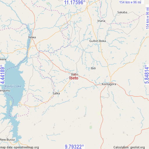
Ibeto GPS coordinates[2]
10° 29' 7.296" North, 5° 8' 42.036" East
| Map corner | latitude | longitude |
|---|---|---|
| Upper-left | 11.17596°, | 4.44189° |
| Center: | 10.48536°, | 5.14501° |
| Lower-right: | 9.79322°, | 5.84814° |
| Map W x H: | 153.7×153.7 km | = 95.5×95.5mi |
| max Lat: | 13.7543° ⇑31.2% North |
| Ibeto: | 10.48536° |
| min Lat: | ⇓68.8% South 4.31231° |
| min Long | Ibeto | max Long |
| 2.73333° | 5.14501° | 14.46552° |
| W 20.7%⇐ | ⇒79.3% E |
Elevation
Elevation of Ibeto is 344 m = 1129 ft, and this is 47.5 m = 156 ft above average elevation for this country.
| Max E: |
1599 m = 5246 ft | 40.2% |
| Ibeto | 344 m 1129 ft | |
| Avg. | 296.5 m = 973 ft | |
Min E: |
2 m = 7 ft | 59.8% |
See also: Nigeria elevation on elevation.city.
Geographical zone
Ibeto is located in North Torrid zone (between Equator and Tropic of Cancer). Distance of Equator is 1165.9 km =724.5 mi to South.| Distance of | km | miles | from Ibeto |
|---|---|---|---|
| North Pole | 8841.2 | 5493.7 | to North |
| Arctic Circle | 6235.3 | 3874.4 | to North |
| Tropic Cancer | 1440.1 | 894.8 | to North |
| Equator | 1165.9 | 724.5 | to South |


Nearby cities:
15 places around Ibeto: (largest is in red/bold)
• Agwara
66.3 km =41.2 mi,  291°
291°
• Auna
56.8 km =35.3 mi,  234°
234°
• Bangi
84 km =52.2 mi,  62°
62°
• Bin Yauri
49.2 km =30.6 mi,  312°
312°
• Duku
87.4 km =54.3 mi,  342°
342°
• Kontagora
36.8 km =22.9 mi,  104°
104°
• Mashegu
89.8 km =55.8 mi,  129°
129°
• Nasko
26.9 km =16.7 mi,  272°
272°
• New Bussa
96.4 km =59.9 mi, 226°
• New Shagunnu
75.7 km =47 mi,  257°
257°
• Rijau
69.8 km =43.4 mi,  9°
9°
• Sakaba
81.1 km =50.4 mi,  37°
37°
• Ukata
83.7 km =52 mi, 62°
• Wara
63.8 km =39.6 mi,  243°
243°
• Yelwa
58.7 km =36.5 mi, 311°
Sources, notices
• [Note1] Compared only with cities in Nigeria existing in our database
• [Src1] Map data: © OpenStreetMap contributors (CC-BY-SA)
• [Src2] Other city data from geonames.org with taken over terms of usage.
• [Src3] Geographical zone / Annual Mean Temperature by Robert A. Rohde @ Wikipedia
