Nasko geodata
Nasko (Niger) is a seat of a second-order administrative division; located in Nigeria in Africa/Lagos (GMT+1) time zone. In our database, there are 451 cities with bigger population. Compared to other cities in Nigeria, 69% of cities are located further ↓South; 82.7% of cities are located further →East and 52.6% of cities have higher elevation than Nasko. Note1


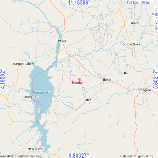
Nasko GPS coordinates[2]
10° 29' 43.404" North, 4° 53' 56.544" East
| Map corner | latitude | longitude |
|---|---|---|
| Upper-left | 11.18596°, | 4.19592° |
| Center: | 10.49539°, | 4.89904° |
| Lower-right: | 9.80327°, | 5.60217° |
| Map W x H: | 153.7×153.7 km | = 95.5×95.5mi |
| max Lat: | 13.7543° ⇑31% North |
| Nasko: | 10.49539° |
| min Lat: | ⇓69% South 4.31231° |
| min Long | Nasko | max Long |
| 2.73333° | 4.89904° | 14.46552° |
| W 17.3%⇐ | ⇒82.7% E |
Elevation
Elevation of Nasko is 269 m = 883 ft, and this is 27.5 m = 90 ft below average elevation for this country.
| Max E: |
1599 m = 5246 ft | 52.6% |
| Avg. | 296.5 m = 973 ft | |
| Nasko | 269 m = 883 ft | |
Min E: |
2 m = 7 ft | 47.4% |
See also: Nigeria elevation on elevation.city.
Geographical zone
Nasko is located in North Torrid zone (between Equator and Tropic of Cancer). Distance of Equator is 1167 km =725.1 mi to South.| Distance of | km | miles | from Nasko |
|---|---|---|---|
| North Pole | 8840.1 | 5493 | to North |
| Arctic Circle | 6234.2 | 3873.8 | to North |
| Tropic Cancer | 1438.9 | 894.1 | to North |
| Equator | 1167 | 725.1 | to South |


Nearby cities:
15 places around Nasko: (largest is in red/bold)
• Agwara
41.9 km =26 mi,  304°
304°
• Auna
39.2 km =24.4 mi,  209°
209°
• Bin Yauri
33.3 km =20.7 mi,  343°
343°
• Duku
82.4 km =51.2 mi,  0°
0°
• Ibeto
26.9 km =16.7 mi,  92°
92°
• Konkwesso
95.8 km =59.5 mi,  294°
294°
• Kontagora
63.4 km =39.4 mi,  99°
99°
• New Bussa
80.1 km =49.8 mi, 212°
• New Shagunnu
50.1 km =31.1 mi,  249°
249°
• Rijau
78.1 km =48.5 mi,  29°
29°
• Sakaba
99 km =61.5 mi,  50°
50°
• Shanga
87.2 km =54.2 mi, 336°
• Wara
42.3 km =26.3 mi,  225°
225°
• Wawa
84.3 km =52.4 mi,  218°
218°
• Yelwa
41.5 km =25.8 mi, 335°
Sources, notices
• [Note1] Compared only with cities in Nigeria existing in our database
• [Src1] Map data: © OpenStreetMap contributors (CC-BY-SA)
• [Src2] Other city data from geonames.org with taken over terms of usage.
• [Src3] Geographical zone / Annual Mean Temperature by Robert A. Rohde @ Wikipedia
