Yelwa geodata
Yelwa (Kebbi) is a seat of a second-order administrative division; located in Nigeria in Africa/Lagos (GMT+1) time zone. In our database, there are 451 cities with bigger population. Compared to other cities in Nigeria, 71.5% of cities are located further ↓South; 84.5% of cities are located further →East and 68.5% of cities have higher elevation than Yelwa. Note1


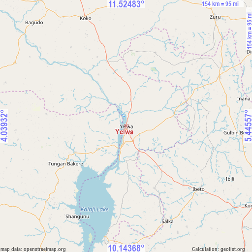
Yelwa GPS coordinates[2]
10° 50' 6.18" North, 4° 44' 32.784" East
| Map corner | latitude | longitude |
|---|---|---|
| Upper-left | 11.52483°, | 4.03932° |
| Center: | 10.83505°, | 4.74244° |
| Lower-right: | 10.14368°, | 5.44557° |
| Map W x H: | 153.6×153.6 km | = 95.4×95.4mi |
| max Lat: | 13.7543° ⇑28.5% North |
| Yelwa: | 10.83505° |
| min Lat: | ⇓71.5% South 4.31231° |
| min Long | Yelwa | max Long |
| 2.73333° | 4.74244° | 14.46552° |
| W 15.5%⇐ | ⇒84.5% E |
Elevation
Elevation of Yelwa is 155 m = 509 ft, and this is 141.5 m = 464 ft below average elevation for this country.
| Max E: |
1599 m = 5246 ft | 68.5% |
| Avg. | 296.5 m = 973 ft | |
| Yelwa | 155 m = 509 ft | |
Min E: |
2 m = 7 ft | 31.5% |
See also: Nigeria elevation on elevation.city.
Geographical zone
Yelwa is located in North Torrid zone (between Equator and Tropic of Cancer). Distance of Equator is 1204.7 km =748.6 mi to South.| Distance of | km | miles | from Yelwa |
|---|---|---|---|
| North Pole | 8802.3 | 5469.5 | to North |
| Arctic Circle | 6196.4 | 3850.3 | to North |
| Tropic Cancer | 1401.2 | 870.7 | to North |
| Equator | 1204.7 | 748.6 | to South |


Nearby cities:
15 places around Yelwa: (largest is in red/bold)
• Agwara
22.7 km =14.1 mi,  230°
230°
• Auna
72 km =44.7 mi,  181°
181°
• Bagudo
84.7 km =52.6 mi,  318°
318°
• Besse
58.8 km =36.5 mi, 324°
• Bin Yauri
9.5 km =5.9 mi,  127°
127°
• Duku
48.1 km =29.9 mi,  21°
21°
• Ibeto
58.7 km =36.5 mi, 131°
• Konkwesso
70.4 km =43.7 mi,  271°
271°
• Mahuta
84 km =52.2 mi, 18°
• Nasko
41.5 km =25.8 mi,  155°
155°
• New Shagunnu
62.7 km =39 mi,  208°
208°
• Rijau
63.5 km =39.5 mi,  61°
61°
• Shanga
45.7 km =28.4 mi,  337°
337°
• Wara
68.6 km =42.6 mi,  190°
190°
• Zuru
85.7 km =53.3 mi,  38°
38°
Sources, notices
• [Note1] Compared only with cities in Nigeria existing in our database
• [Src1] Map data: © OpenStreetMap contributors (CC-BY-SA)
• [Src2] Other city data from geonames.org with taken over terms of usage.
• [Src3] Geographical zone / Annual Mean Temperature by Robert A. Rohde @ Wikipedia
