Ojoto geodata
Ojoto (Anambra) is a seat of a second-order administrative division; located in Nigeria in Africa/Lagos (GMT+1) time zone. In our database, there are 451 cities with bigger population. Compared to other cities in Nigeria, 83% of cities are located further ↑North; 59.3% of cities are located further →East and 70.6% of cities have higher elevation than Ojoto. Note1


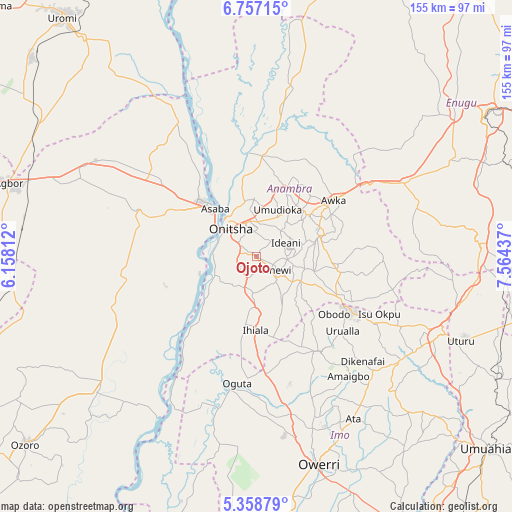
Ojoto GPS coordinates[2]
6° 3' 30.312" North, 6° 51' 40.464" East
| Map corner | latitude | longitude |
|---|---|---|
| Upper-left | 6.75715°, | 6.15812° |
| Center: | 6.05842°, | 6.86124° |
| Lower-right: | 5.35879°, | 7.56437° |
| Map W x H: | 155.5×155.5 km | = 96.6×96.6mi |
| max Lat: | 13.7543° ⇑83% North |
| Ojoto: | 6.05842° |
| min Lat: | ⇓17% South 4.31231° |
| min Long | Ojoto | max Long |
| 2.73333° | 6.86124° | 14.46552° |
| W 40.7%⇐ | ⇒59.3% E |
Elevation
Elevation of Ojoto is 143 m = 469 ft, and this is 153.5 m = 504 ft below average elevation for this country.
| Max E: |
1599 m = 5246 ft | 70.6% |
| Avg. | 296.5 m = 973 ft | |
| Ojoto | 143 m = 469 ft | |
Min E: |
2 m = 7 ft | 29.4% |
See also: Nigeria elevation on elevation.city.
Geographical zone
Ojoto is located in North Torrid zone (between Equator and Tropic of Cancer). Distance of Equator is 673.6 km =418.6 mi to South.| Distance of | km | miles | from Ojoto |
|---|---|---|---|
| North Pole | 9333.4 | 5799.5 | to North |
| Arctic Circle | 6727.5 | 4180.3 | to North |
| Tropic Cancer | 1932.3 | 1200.7 | to North |
| Equator | 673.6 | 418.6 | to South |


Nearby cities:
15 places around Ojoto: (largest is in red/bold)
• Abagana
20.7 km =12.9 mi,  44°
44°
• Agulu
22.6 km =14 mi,  78°
78°
• Asaba
21.1 km =13.1 mi,  317°
317°
• Atani
13.5 km =8.4 mi,  247°
247°
• Enugu-Ukwu
20.3 km =12.6 mi,  51°
51°
• Igbo-Ukwu
18.2 km =11.3 mi,  104°
104°
• Neni
18.5 km =11.5 mi, 77°
• Nkpor
10.8 km =6.7 mi,  341°
341°
• Nnewi
7.6 km =4.7 mi,  124°
124°
• Ogidi
10.4 km =6.5 mi,  1°
1°
• Onitsha
13.2 km =8.2 mi, 320°
• Ozubulu
11.3 km =7 mi,  184°
184°
• Ukpo
20.9 km =13 mi,  33°
33°
• Ukpor
15 km =9.3 mi,  149°
149°
• Uruobo-Okija
17.7 km =11 mi,  186°
186°
Sources, notices
• [Note1] Compared only with cities in Nigeria existing in our database
• [Src1] Map data: © OpenStreetMap contributors (CC-BY-SA)
• [Src2] Other city data from geonames.org with taken over terms of usage.
• [Src3] Geographical zone / Annual Mean Temperature by Robert A. Rohde @ Wikipedia
