Agbor geodata
Agbor (Delta) is a seat of a second-order administrative division; located in Nigeria in Africa/Lagos (GMT+1) time zone. With population of 67,610 people, there are 139 cities with bigger population in this country. Compared to other cities in Nigeria, 80.9% of cities are located further ↑North; 68.4% of cities are located further →East and 73.3% of cities have higher elevation than Agbor. Note1


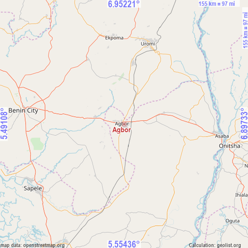
Agbor GPS coordinates[2]
6° 15' 13.5" North, 6° 11' 39.12" East
| Map corner | latitude | longitude |
|---|---|---|
| Upper-left | 6.95221°, | 5.49108° |
| Center: | 6.25375°, | 6.1942° |
| Lower-right: | 5.55436°, | 6.89733° |
| Map W x H: | 155.4×155.4 km | = 96.6×96.6mi |
| max Lat: | 13.7543° ⇑80.9% North |
| Agbor: | 6.25375° |
| min Lat: | ⇓19.1% South 4.31231° |
| min Long | Agbor | max Long |
| 2.73333° | 6.1942° | 14.46552° |
| W 31.6%⇐ | ⇒68.4% E |
Elevation
Elevation of Agbor is 130 m = 427 ft, and this is 166.5 m = 546 ft below average elevation for this country.
| Max E: |
1599 m = 5246 ft | 73.3% |
| Avg. | 296.5 m = 973 ft | |
| Agbor | 130 m = 427 ft | |
Min E: |
2 m = 7 ft | 26.7% |
See also: Agbor elevation on elevation.city.
Geographical zone
Agbor is located in North Torrid zone (between Equator and Tropic of Cancer). Distance of Equator is 695.4 km =432.1 mi to South.| Distance of | km | miles | from Agbor |
|---|---|---|---|
| North Pole | 9311.7 | 5786 | to North |
| Arctic Circle | 6705.8 | 4166.8 | to North |
| Tropic Cancer | 1910.6 | 1187.2 | to North |
| Equator | 695.4 | 432.1 | to South |


Nearby cities:
15 places around Agbor: (largest is in red/bold)
• Abraka
52.5 km =32.6 mi,  190°
190°
• Abudu
18.7 km =11.6 mi,  284°
284°
• Akwukwu-Igbo
45.3 km =28.1 mi,  75°
75°
• Ehor
46.5 km =28.9 mi,  329°
329°
• Ekpoma
54.7 km =34 mi,  353°
353°
• Idogbo
53.2 km =33.1 mi,  271°
271°
• Igueben
39.1 km =24.3 mi,  7°
7°
• Irrua
53.7 km =33.4 mi,  3°
3°
• Issele-Uku
31.9 km =19.8 mi, 77°
• Obiaruku
45.5 km =28.3 mi, 185°
• Ogwashi-Uku
37.5 km =23.3 mi,  102°
102°
• Owa-Oyibu
7.9 km =4.9 mi,  176°
176°
• Ubiaja
49.4 km =30.7 mi,  25°
25°
• Umunede
12.8 km =8 mi, 84°
• Uromi
51.9 km =32.2 mi,  17°
17°
Sources, notices
• [Note1] Compared only with cities in Nigeria existing in our database
• [Src1] Map data: © OpenStreetMap contributors (CC-BY-SA)
• [Src2] Other city data from geonames.org with taken over terms of usage.
• [Src3] Geographical zone / Annual Mean Temperature by Robert A. Rohde @ Wikipedia
